

Gaziantep: Production, Wealth, and Continuity in Southeastern Anatolia
Gaziantep is positioned at a critical intersection between Central Anatolia and northern Mesopotamia, where geography directly shapes economic function. The city lies along historical transit corridors that connect inland production zones with southern trade networks, including routes extending toward Aleppo and the eastern Mediterranean. This location establishes Gaziantep not as an endpoint, but as an operational node within a broader regional system.
Across historical periods, this role remains consistent. Settlement patterns, commercial activity, and urban development align with the same underlying logic: movement of goods, processing of resources, and redistribution through established networks. Agricultural output from surrounding plains enters the city, where it is transformed through craft and industrial processes before re-entering circulation.
This continuity defines Gaziantep’s structural identity. Hellenistic foundations, Roman expansion, and later Ottoman integration do not replace one another as separate phases. They reinforce an existing system centered on production and exchange. Material culture, architectural remains, and urban organization reflect this continuity rather than rupture.
The city’s historical depth and present-day economic capacity operate within the same framework. Gaziantep does not derive its significance from isolated monuments or singular events. Its relevance emerges from sustained functionality, where geography, labor, and knowledge remain aligned over time.
For more detailed information about Southeastern Anatolia, you can visit our Southeastern Turkey Travel Guide page.
Where Is Gaziantep and Why It Matter
Gaziantep is located in southeastern Turkey, at the transition between the Anatolian plateau and the northern edge of Mesopotamia. This position defines the conditions under which the city developed. Elevation decreases toward the south, opening into fertile plains that have supported agriculture and settlement for thousands of years, while northern routes connect to inland Anatolia and its production networks. Gaziantep Turkey therefore operates within a geographic threshold that links plateau systems with Mesopotamian lowlands.
This dual orientation shapes how the city operates. To the south, proximity to Mesopotamian lowlands sustains agricultural continuity and access to long-standing trade routes. To the north and west, connections to the Anatolian interior allow integration into wider economic and political systems. Gaziantep Turkey functions between these zones, receiving, processing, and redistributing goods across them.
Climate reinforces this balance. Semi-arid conditions, combined with seasonal cycles and controlled water use, favor specific types of cultivation. Pistachio, cereals, and olives reflect long-term adaptation rather than random selection. These products are directly linked to the city’s processing capacity and commercial identity.
Topography also supports movement. The surrounding terrain allows stable transit compared to more restrictive landscapes. This enables continuity in trade routes across different periods, even as political control changes. Routes may shift in detail, but the corridors remain active.
Gaziantep’s significance emerges from this alignment between land, movement, and production. Geography does not sit in the background. It actively shapes how the city produces, trades, and sustains itself over time.
Where is Gaziantep Turkey is not a simple map question. It is a structural question, because location here is the reason production and exchange remain continuous.
A City Built on Trade and Geography
Gaziantep developed through a direct relationship between geography and trade. Its position along routes connecting Anatolia with northern Syria and the eastern Mediterranean created continuous movement of goods. This movement required more than transit. It required places where materials could be stored, processed, exchanged, and redistributed. The city formed around these needs. Gaziantep Turkey developed as a response to this continuous movement and logistical necessity.
Trade in Gaziantep operates together with production. Goods arriving from surrounding agricultural zones or distant regions do not remain in their original state. They are transformed through craft, technique, and labor. Value is added within the city before goods move onward. This process defines the economic character of Gaziantep. Within this structure, Gaziantep Turkey operates as both a processing and redistribution center.
The urban structure reflects this reality. Markets, workshops, and storage areas are organized in relation to one another. Commercial districts are not separate from production spaces. They function together. Traditional bazaars, including Bakırcılar Çarşısı, maintain this continuity. Metal is shaped, sound fills the streets, and production remains visible within everyday life. This visibility reinforces how Gaziantep Turkey preserves production within the urban fabric.
This pattern extends across historical periods. Changes in political authority do not alter the city’s core function. Under different administrations, the same activity continues: receiving materials, processing them, and redistributing them through established routes.
Gaziantep’s economic strength is grounded in this continuity. It does not depend on a single moment of prosperity. It is sustained by an ongoing relationship between location, production, and exchange, where each element supports the others over time.
Gaziantep Turkey is valuable for travelers because what they see is not staged. They are stepping into an active production city, where craft and market logic remain visible.
Zeugma: A City of Crossing, Wealth and Collapse
Zeugma was established in the late 4th century BCE (Before Common Era) during the Hellenistic period, at a strategic crossing point on the Euphrates River. Its name, derived from the Greek word for “bridge” or “crossing,” reflects its primary function. This was a controlled point of passage where movement between regions could be regulated, taxed, and secured. Within this regional system, Gaziantep Turkey later emerged as a connected center of production and redistribution.
The location determined its growth. Positioned between Anatolia and Mesopotamia, Zeugma became a key node within long-distance trade routes. Caravans, military units, and merchants moving across the river required infrastructure, security, and administrative control. The city developed to meet these demands, evolving into a center of economic and logistical importance. This network structure continues to inform how Gaziantep Turkey operates within the same geography.
Under Roman rule, Zeugma reached its peak. Wealth accumulated through trade is visible in the remains of large villas, many of which were built with courtyards, reception spaces, and private bath complexes. These were not isolated residences. They formed part of an urban environment shaped by prosperity and social hierarchy. The presence of high-ranking officials and military units further reinforced the city’s strategic and economic value.
Material evidence from these villas reveals a lifestyle built on both function and display. Imported goods, refined architectural elements, and extensive mosaic programs indicate a level of wealth directly tied to the city’s position within trade networks. Economic flow translated into cultural and visual expression. These patterns of wealth and movement are structurally echoed in Gaziantep Turkey today.
This trajectory was not permanent. In the 3rd century CE (Common Era), Sasanian attacks led to large-scale destruction. Parts of the city were abandoned, while others were gradually covered by sediment from the Euphrates. This process, while marking the end of Zeugma as a functioning city, also contributed to the preservation of its material remains.
Today, Zeugma represents a concentrated example of how geography, trade, and political power intersect. Its rise is linked to control over movement and exchange. Its decline reflects the vulnerability of that position. What remains provides direct evidence of a system where wealth, strategy, and location operated together.
Gaziantep Turkey connects to Zeugma not as a side excursion, but as proof that the region’s wealth historically followed control of corridors and crossings.

Zeugma Mosaics: Discovery, Preservation and Meaning
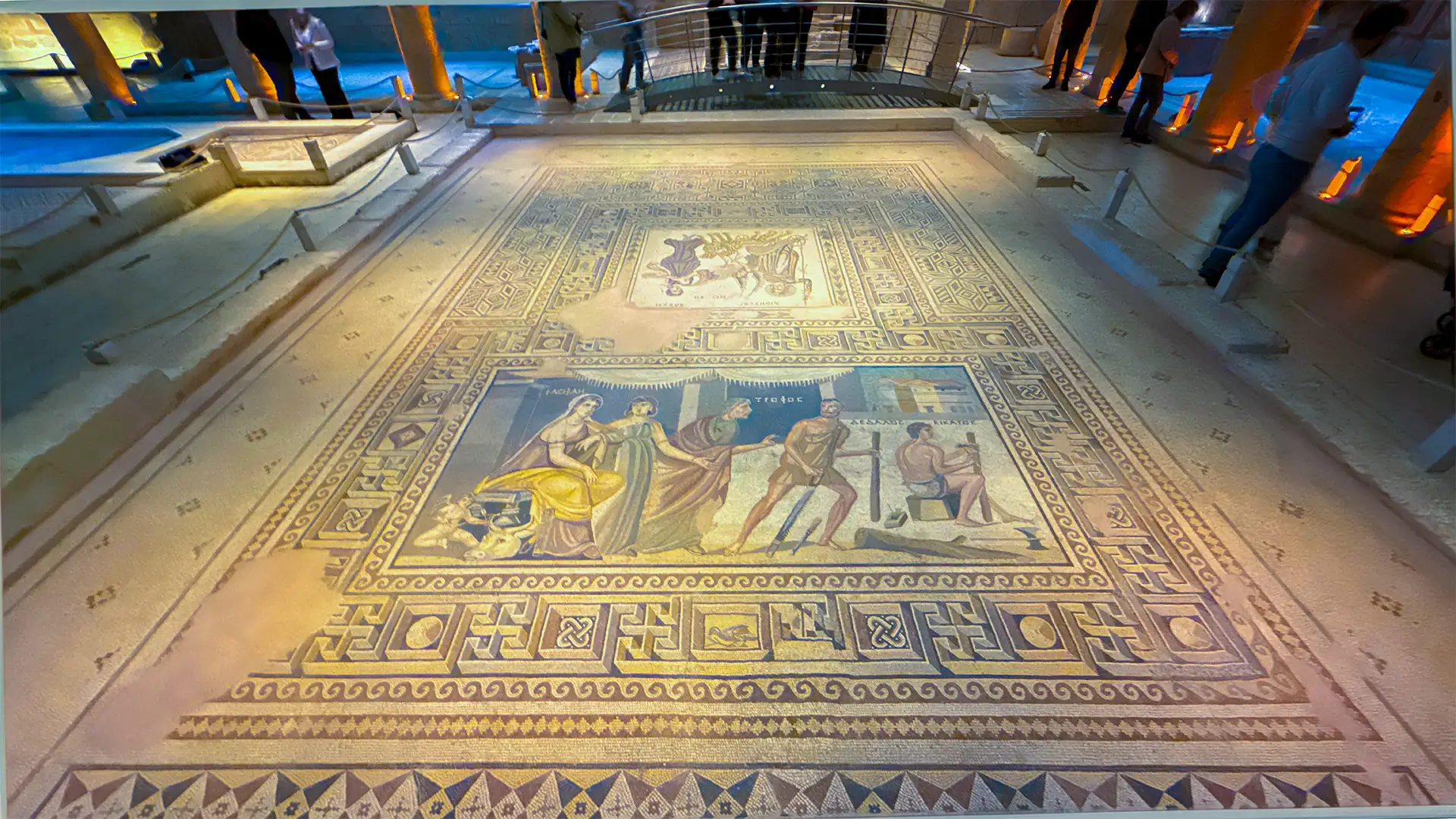
The mosaics displayed today in the Zeugma Mosaic Museum originate from Roman villas located in the ancient city of Zeugma, positioned along the Euphrates River. These works were part of domestic architectural programs, designed for floors and reception spaces rather than isolated display. Their current presence in the museum is the result of systematic archaeological work carried out under urgent conditions.
Large-scale excavations intensified in the late 20th and early 21st centuries, particularly in response to the construction of the Birecik Dam. Rising water levels posed a direct threat to the site. Archaeological teams conducted rapid rescue excavations to document and recover material remains before submersion. During this process, numerous mosaics were uncovered, carefully lifted, and transported for conservation.
The transition from site to museum was not simply logistical. It involved stabilization, cleaning, and reconstruction. Fragmented sections were reassembled, and original compositions were restored based on structural analysis. What is seen today represents both the original Roman workmanship and the outcome of modern conservation practice.
Within their original context, these mosaics formed part of a controlled interior environment. They were placed in areas designed for reception and movement, where visibility played a role in social interaction. Their themes and compositions reflect the cultural and intellectual references of the Roman elite rather than local traditions.
Among the most recognized works is the Gypsy Girl Mosaic. The composition is unusually restrained. There is no full scene, no architectural setting, no surrounding narrative. The focus is entirely on the face. The gaze is direct, almost persistent, creating the impression that it follows the viewer. This effect comes from precise control of shadow and detail, especially around the eyes.
Who she represents remains uncertain. Interpretations range from a mythological figure to a personification, yet none are definitive. This uncertainty does not weaken the image. It strengthens it. The absence of a fixed identity allows the figure to remain open, holding attention without resolution. The story is not given. It is suspended.
A different visual language appears in the mosaic of Oceanus and Tethys. Oceanus is depicted as a powerful figure associated with the waters that encircle the world, while Tethys, a Titan, is linked to freshwater systems and generative continuity within Greek mythology. This composition does not reflect a local belief tradition. It belongs to the shared cultural vocabulary of the Roman world.
Here, the image expands beyond the individual. Marine elements, flowing forms, and balanced composition create a sense of movement and continuity. The subject is not a single figure, but a larger idea. Water is presented as an organizing force, connected to life, order, and stability.
These mosaics were never neutral. They were part of how a Roman household presented itself. Guests entering these spaces would encounter images that reflected education, cultural awareness, and intellectual alignment with the wider Mediterranean world.
Things to do in Gaziantep Turkey often starts with the museum, because it is both visual impact and historical logic in one place.
Rumkale: Fortress, Landscape and Control
Rumkale is located at a strategic point along the Euphrates River, where steep cliffs meet the water and create a naturally defensible position. This setting is not incidental. It defines the function of the site. Control here is achieved through elevation, visibility, and limited access rather than large-scale fortification alone. Within this broader system, Gaziantep Turkey can be understood through similar principles of spatial control and movement.
The fortress occupies a narrow promontory surrounded by the river on multiple sides. Movement toward the site is restricted, and approach routes are easily monitored. This geography establishes Rumkale as a point of observation and control, where passage along the river can be tracked and, when necessary, regulated. This same corridor logic continues to influence how Gaziantep Turkey operates within regional networks.
Historical layers reinforce this role. The site has been used across different periods, including Hellenistic, Roman, and later medieval phases. Each period adapts the location rather than redefining it. Structural additions respond to the same condition: maintaining oversight of movement along the Euphrates corridor. These layered adaptations mirror the continuity seen in Gaziantep Turkey.
Rumkale is also associated with early Christian traditions. It is linked to the presence of religious communities and later ecclesiastical use, including references to Saint John and manuscript activity. These associations add a layer of intellectual and spiritual continuity to a site already defined by strategic importance.
What distinguishes Rumkale is the alignment between landscape and function. The fortress does not impose control on the environment. It operates through it. The cliffs, the river, and the limited access points form a system where defense and observation are integrated into the terrain itself.
Today, access to Rumkale often occurs by boat, particularly from the nearby settlement of Halfeti. This mode of approach reflects the same spatial reality that defined the site historically. The river remains the primary axis of movement, and the fortress continues to be understood in relation to it.
Rumkale is not an isolated monument. It represents a long-standing relationship between geography and authority, where control is established through position rather than scale, and where continuity is maintained by adapting to the same landscape over time.
Gaziantep Turkey becomes more legible when Rumkale is read as corridor control, because that corridor logic is the same logic that shapes city production.
Agriculture and Pistachio Culture in Gaziantep, Turkey
Agriculture in Gaziantep operates within defined environmental limits, shaped by semi-arid conditions, seasonal variability, and long-term adaptation. Production is not based on maximum diversity, but on selecting crops that can sustain continuity under heat, limited water, and fluctuating yields. Pistachios, cereals such as wheat and barley, vineyards, olives, and a wide range of vegetables form the core of this system. Within this system, Gaziantep Turkey reflects long-term agricultural continuity tied to environmental limits.
Among these, certain crops carry structural importance beyond volume. Eggplant, locally referred to as balcan, is one of the most consistent elements within regional cultivation. Its repeated use across local dishes establishes a direct link between agricultural production and culinary identity, where what is grown is closely aligned with how food is prepared. This alignment strengthens how Gaziantep Turkey connects agriculture directly with cuisine.
Pistachio defines the system at a deeper level. Known as Antep fıstığı, it is not only a cultivated product but part of a broader botanical and agricultural network. In this region, pistachio trees are closely related to wild species such as menengiç (Pistacia terebinthus) and buttum (Pistacia khinjuk). These wild trees play a critical role as rootstock, onto which cultivated pistachio varieties are grafted. This practice allows trees to adapt to poor soils and dry conditions, ensuring long-term resilience.
Cultivation follows extended time cycles. Pistachio trees require years before reaching productive capacity, and yields often alternate between high and low output seasons. This pattern is not a limitation but an expected rhythm within the system. Production is planned across years rather than seasons. This long-cycle planning is a defining characteristic of Gaziantep Turkey agricultural systems.
Historically, pistachio cultivation in this region developed under dry farming conditions, often on marginal land. Unlike irrigated large-scale plantations seen elsewhere, local production adapted to scarcity. Recent irrigation developments have expanded capacity, yet the underlying structure remains based on resilience rather than abundance.
The connection between land and city is continuous. Agricultural products enter Gaziantep as raw material and move through stages of processing, distribution, and transformation. Pistachio, in particular, passes through controlled stages of harvesting, drying, sorting, and preparation, forming the basis for confectionery, cuisine, and export. This processing chain is central to how Gaziantep Turkey sustains its economic identity.
This structure defines Gaziantep’s agricultural identity. What begins in orchards and fields does not remain there. It continues into kitchens, workshops, and markets, forming a system where production, knowledge, and usage remain directly connected.
Gaziantep Turkey food becomes more understandable when pistachio is treated as a long cycle crop tied to processing, not just a flavor.
Gaziantep Cuisine: A UNESCO Recognized Culinary System
Gaziantep cuisine operates through a structured relationship between ingredients, technique, and timing. This approach was formally recognized when Gaziantep was included in the UNESCO Creative Cities Network for gastronomy. The recognition reflects a system built on continuity and technical precision rather than individual dishes. UNESCO means United Nations Educational, Scientific and Cultural Organization. Gaziantep Turkey food is structured around technique, timing, and ingredient control rather than variety alone.
Soup culture forms one of the entry points into this system. In Gaziantep Turkey, Beyran is prepared through a controlled, multi-stage process. Lamb is slowly boiled to produce a concentrated broth, which is then combined with rice and garlic and reheated at high temperature in copper vessels at the moment of service. This final step is not simple reheating. It reactivates the structure of the dish.
A more intricate preparation appears in yuvalama soup. Small, hand-shaped meatballs are combined with chickpeas and a yogurt-based broth. The scale of preparation increases the level of precision required. Size, consistency, and timing determine the final result.
This level of control becomes more visible in içli köfte. The outer shell is made from finely processed bulgur, shaped into a thin and stable layer. The filling consists of minced meat, onions, and spices. The critical point lies in maintaining structural integrity while achieving thinness. Whether boiled or fried, the form must remain intact. This is not casual preparation. It is a controlled process.
Kebabs operate through direct heat. Ali Nazik kebab is structured in layers. Roasted eggplant is combined with yogurt to form a soft base, while seasoned lamb is placed above it. The lower layer absorbs and balances the intensity of the meat, creating a unified composition rather than separate elements.
Dough-based dishes follow a different logic. Lahmacun is built on a thin layer of dough with a precisely distributed mixture of minced meat, garlic, and vegetables. The objective is not thickness but uniform flavor across the surface. Firik pilavı, made from smoked green wheat, introduces a different dimension through its distinctive aroma, often combined with chickpeas and meat.
Seasonality appears in preserved vegetable dishes such as dried eggplant and pepper dolma. Vegetables prepared during the summer are rehydrated and filled during the winter. Sour elements such as pomegranate molasses and sumac establish balance within the filling. The dish reflects continuity across seasons rather than immediate consumption.
Desserts require the highest level of control. Baklava is defined by the precision of its layers, the quality of clarified butter, and the proportion of pistachio. Each stage, from dough preparation to syrup application, determines the final structure. Katmer, by contrast, is prepared quickly, combining thin dough with clotted cream and pistachio, typically consumed in the early hours of the day.
The sequence concludes with menengiç coffee, derived from wild pistachio varieties. It contains no caffeine and has a softer, oil-rich texture. Its role is not separate from the meal but part of the overall structure, completing the experience.
Gaziantep, Turkey cuisine does not rely on individual recipes for identity. It functions as a system where ingredients, technique, and knowledge operate together, allowing continuity across generations while maintaining precision in every stage.
Bakırcılar Çarşısı: Craft, Sound and Urban Production
Bakırcılar Çarşısı represents the continuation of production within the urban environment. This is not a marketplace defined only by exchange. It is a working space where materials are shaped, refined, and transformed through skilled labor. Within this environment, Gaziantep Turkey preserves production as a visible and active process.
Copper has a long-standing role in Gaziantep. Its use extends beyond decorative objects into functional items such as cooking vessels, trays, and service ware. Production follows a sequence of processes, including shaping, hammering, engraving, and polishing. Each stage requires control, repetition, and experience. These processes remain integral to how Gaziantep Turkey sustains its craft tradition.
The organization of the bazaar reflects this activity. Workshops and retail spaces exist side by side, without separation between production and sale. What is displayed is often produced on site. This proximity maintains visibility, allowing the process itself to become part of the environment. This structure reinforces the production identity of Gaziantep Turkey.
Sound plays a defining role. The rhythmic striking of metal is constant, creating an acoustic layer that reflects ongoing work. This is not incidental noise. It signals continuity, where production remains active throughout the day.
Craftsmanship in Bakırcılar Çarşısı is based on transmission. Techniques are passed through practice rather than formal instruction. Skills are observed, repeated, and refined within the workshop. This process ensures consistency while allowing individual variation, a pattern that continues across Gaziantep Turkey.
The relationship between this space and the broader city is direct. Objects produced here enter daily use, particularly within kitchens and hospitality settings. In Gaziantep Turkey, copper vessels are not symbolic. They are functional components of the same system that connects agriculture, cuisine, and urban life.
Bakırcılar Çarşısı therefore operates as more than a commercial district. It is a visible extension of Gaziantep’s production culture, where material, technique, and daily practice remain closely aligned.
Things to do in Gaziantep Turkey becomes stronger when this bazaar is presented as living production, not only shopping.
Understanding Gaziantep Through Structure
Gaziantep is best understood through how it produces. The city’s identity emerges from the interaction between land, technique, and use, where raw materials are continuously transformed rather than simply consumed.
This continuity is visible across different scales. Agricultural products move into kitchens, techniques define outcomes, and crafted objects remain in daily use. What connects these layers is not coincidence, but consistency in how production is approached and sustained.
For this reason, Gaziantep is not defined by isolated highlights. Its clarity comes from observing how these elements operate together, where each part gains meaning through its relationship with the others.
Adventus approaches the city through this perspective, focusing on connections rather than fragments. When these relationships are recognized, Gaziantep becomes legible as a whole, not as separate experiences.
gaziantep turkey is the cluster that explains Southeastern Anatolia through production continuity, and that is exactly why it supports the pillar architecture.
Things to Do in Gaziantep Turkey
Understanding Gaziantep through structure is essential, but experience completes it. The city offers a set of locations where production, history, and daily life become directly visible.
The Zeugma Mosaic Museum presents the clearest connection to the region’s Roman past, where preserved mosaics reveal both artistic and economic structure.
Bakırcılar Çarşısı allows direct observation of ongoing production. Copper workshops operate continuously, making craft visible rather than symbolic.
The historic city center connects markets, mosques, and traditional streets into a single urban system where movement and trade remain aligned.
Local cuisine is not an optional activity but a central experience. Sampling dishes such as kebabs, soups, and pistachio-based desserts reveals how agriculture and technique are directly connected.
Each of these locations should not be seen as isolated stops, but as parts of a continuous system that defines Gaziantep Turkey.
Best Time to Visit and Weather Planning
Gaziantep Turkey’s weather matters because heat and dryness shape both movement and daily rhythm.
For planning purposes, spring and autumn generally offer more comfortable day temperatures for walking museum zones, old city routes, and bazaar corridors. Summer heat can be intense, and winter conditions tend to be calmer than Central Anatolia, with shorter daylight hours affecting pacing.
Gaziantep Turkey weather should be treated as an itinerary design variable, not a footnote, because culinary mornings and historic center walking are timing dependent.
FAQ: Visiting Gaziantep
Is it possible to visit Gaziantep with a structured private tour?
Yes. Gaziantep can be explored through privately designed programs that focus on history, cuisine, and local production. These tours allow a more detailed understanding of the city beyond standard visits.
How many days are needed in Gaziantep, Turkey?
A minimum of one full day allows coverage of key locations such as Zeugma Mosaic Museum, Bakırcılar Çarşısı, and the historic center. A longer stay provides more depth, particularly for culinary experiences.
When is the best time to visit Gaziantep?
Spring and autumn offer balanced weather conditions. Summers can be hot, while winters remain relatively mild compared to central Anatolia.
Can Gaziantep be combined with other regions?
Yes. Gaziantep is often part of broader regional routes that include Şanlıurfa and surrounding historical sites. These combinations provide a more complete understanding of the region.
Can Gaziantep be combined with other regions?
Yes. Gaziantep works particularly well as the western gateway to a broader Southeastern Turkey route.
For a shorter regional journey, the Gaziantep to Göbeklitepe Tour connects Gaziantep with Halfeti, Şanlıurfa and Göbeklitepe over three days, combining culinary culture, the Euphrates landscape and prehistoric archaeology.
Travellers who want Gaziantep to form part of a deeper journey across Turkey can instead follow the 15-Day Turkey Tour • Istanbul, Cappadocia & Mesopotamia. After Istanbul and four nights in Cappadocia, the route continues overland to Gaziantep before following the Euphrates through Halfeti and Şanlıurfa, then continuing to Göbeklitepe, Mardin and Mount Nemrut.
The choice therefore depends on the scale of the trip: Gaziantep can anchor a focused Southeastern itinerary or become the point where a longer journey through Turkey enters the landscapes of Upper Mesopotamia.
WRITTEN BY

Nisa Buket Dağdelen
Operations Director & Tour Guide
LinkedIn Profile

Hüseyin Pekgöz
Founder & Managing Partner
LinkedIn Profile
Adventus Travel Company


