
The fairy chimneys of Cappadocia are the most recognisable features of a landscape shaped by volcanic activity, erosion and centuries of human adaptation.
Across valleys around Göreme, Ürgüp, Uçhisar, Çavuşin and Zelve, volcanic rock has been sculpted into cones, pillars, ridges and capped formations. People later carved the same soft rock into homes, churches, monasteries, dovecotes and storage spaces, creating the close relationship between geology and human settlement that defines Cappadocia today.
Their story is therefore larger than the unusual shapes visible from a viewpoint. Understanding how the rock formed, why erosion produces different types of fairy chimneys and how people adapted these formations makes the entire Cappadocian landscape easier to read.
For a broader introduction to the region’s history, valleys, cultural sites and practical travel planning, continue with our Cappadocia Travel Guide.
What Are the Fairy Chimneys of Cappadocia?
Fairy chimneys are erosional landforms created within Cappadocia’s volcanic landscape.
In geological terminology, similar formations are often described as hoodoos. They develop where layers of rock respond differently to weathering and erosion, allowing more resistant material to protect softer rock beneath it for a period of time.
The classic Cappadocian example is a tall column or cone of relatively soft volcanic material crowned by a harder cap.
But not every fairy chimney has this mushroom-shaped appearance.
Some are narrow and pointed.
Others form clustered cones.
Some remain connected to larger valley walls, while others stand almost completely isolated.
These differences reflect variations in the volcanic deposits, fractures, slope conditions and the way erosion has progressed in different parts of Cappadocia. Academic research describes fairy chimneys as landforms produced by the differential erosion of ignimbrite layers with different resistance to weathering.
UNESCO similarly describes Göreme and its surroundings as a volcanic landscape sculpted by erosion into valleys, ridges, pinnacles and the formations known as fairy chimneys or hoodoos.

How Did the Fairy Chimneys of Cappadocia Form?
The formation of the fairy chimneys began with volcanic activity across Central Anatolia millions of years before the landscape took its present form.
From approximately the Late Miocene, around 10 million years ago, repeated eruptions spread volcanic ash, pumice and pyroclastic material across large areas of what is now Cappadocia. Over several million years, these deposits created thick sequences of volcanic rock, particularly ignimbrites, across the plateau.
The landscape visitors see today developed much later through erosion.
The important point is that Cappadocia was not created by one volcano erupting once and leaving behind ready-made fairy chimneys.
First came repeated volcanic deposits.
Then came a very long period in which those layers were weathered, fractured and eroded.
From Volcanic Plateau to Fairy Chimney
The process begins with relatively broad volcanic plateaus.
Natural fractures develop within the rock, providing weaknesses along which water and weathering can begin to work.
Rainfall and surface runoff gradually cut into the plateau. Wetting and drying, freezing and thawing, differences in slope and the physical properties of individual rock layers all influence how quickly particular surfaces deteriorate. Research on Cappadocian tuffs shows that fractures and the low durability of some volcanic rocks play an important role in both the formation and continuing stability of fairy chimneys.
As erosion progresses, the plateau becomes divided into ridges, cones and eventually isolated pillars.
This is differential erosion: different rock layers disappear at different rates.
Why Do Some Fairy Chimneys Have Stone Caps?
The familiar mushroom-shaped fairy chimney develops when a relatively resistant rock layer protects softer material beneath it.
The harder upper layer erodes more slowly and acts as a temporary cap.
The softer rock below continues to wear away, but the protected section survives longer than the surrounding material. Over time, this produces the narrow neck and broader cap associated with some of Cappadocia’s best-known formations.
Academic measurements confirm that the cap plays an important role in slowing the erosion of the softer material beneath it. Once the cap is lost, the exposed column can deteriorate much more rapidly.
A fairy chimney is therefore not a permanent geological object.
It is one stage within an erosion process.
Are the Fairy Chimneys Still Changing?
Yes.
The same natural processes that created Cappadocia’s fairy chimneys continue today.
Water, weathering, temperature changes and erosion still affect the volcanic rock. Scientific measurements show that different parts of the landscape erode at different rates and that deterioration accelerates considerably after a protective cap disappears.
Some formations will eventually collapse.
Others will continue developing as surrounding rock is removed.
UNESCO specifically recognises this continuing erosion as part of the natural character of the Cappadocian landscape, while also noting that erosion and visitor pressure create conservation challenges for rock-cut cultural features.
The fairy chimneys should therefore not be imagined as a landscape completed millions of years ago.
Cappadocia is still being shaped.
Where Are the Fairy Chimneys of Cappadocia?
Fairy chimneys occur across the central Cappadocia region, particularly within and around the landscape between Göreme, Uçhisar, Ürgüp, Avanos, Çavuşin and Zelve.
Some of the most accessible concentrations appear in:
- Paşabağ (Monks Valley)
- Zelve
- Devrent Valley
- Love Valley
- Göreme and its surrounding valleys
- Red Valley and Rose Valley
The UNESCO-listed Göreme National Park and the Rock Sites of Cappadocia protect part of this wider volcanic and cultural landscape. UNESCO describes the World Heritage property as extending beyond Göreme itself to include additional rock sites and the underground cities of Kaymaklı and Derinkuyu.
The fairy chimneys do not look identical from one valley to another.
Paşabağ is particularly associated with capped mushroom-like formations.
Love Valley is dominated by tall vertical forms.
Devrent is known for irregular shapes that invite comparisons with animals and familiar objects.
Red and Rose valleys are characterised more strongly by colourful ridges, cones and eroded volcanic slopes.
This variation is one of the main reasons seeing more than one valley gives a much better understanding of Cappadocia than visiting a single panoramic viewpoint.

Continue Exploring Cappadocia
Fairy chimneys are only one part of Cappadocia’s wider volcanic and cultural landscape. These guides, experiences and private tours provide useful next steps depending on how you want to explore the region.
Plan Your Cappadocia Trip
Understand the Landscape & Rock-Cut Heritage
Experience the Landscape
Suggested Private Tours
- Highlights of Cappadocia Tour
- 3 Days Cappadocia Tour
- 5 Days Cappadocia Tour
- Cappadocia Hiking Tour • Valleys & Local Experiences
Why Do Cappadocia’s Fairy Chimneys Have Different Colors?
Cappadocia is often described as a landscape of white, cream, yellow, pink and red rock, but these colours are not simply created by sunlight.
They begin with differences within the volcanic deposits themselves.
Cappadocia’s plateau contains multiple ignimbrite layers produced by separate volcanic events. These layers vary in mineral composition, degree of welding, oxidation, alteration and weathering, which can give neighbouring rock surfaces noticeably different colours. Geological analysis of Turkish ignimbrites has shown that differences between red, grey and darker rock can be associated with factors including cooling conditions and iron oxides.
Sunlight then changes how strongly those colours appear.
This is why the same valley can look relatively pale at midday and much warmer shortly before sunset.
Why Are Red Valley and Rose Valley So Colourful?
Red Valley and Rose Valley provide some of the clearest examples of Cappadocia’s coloured volcanic landscape.
Their exposed rock layers contain variations in volcanic material and mineral alteration, while oxidation contributes to many of the red, orange and pink tones visible across the slopes. Iron-bearing minerals are particularly important in producing reddish colours in volcanic rocks, although the geology of an entire valley should not be reduced to one mineral alone.
The effect becomes more dramatic when the sun is low.
Late-afternoon light strikes the valley walls at a shallower angle, strengthening shadows and making differences between individual rock layers easier to see. The sunlight does not create the red or pink rock, but it can make existing colours appear much more intense.
This is one reason Red and Rose valleys are particularly rewarding near sunset.
The attraction is not simply the sunset itself. It is the way changing light reveals the stratigraphy and texture of the volcanic landscape.
Why Are Some Fairy Chimneys Pale or Grey?
Elsewhere in Cappadocia, exposed tuff and ignimbrite can appear cream, pale yellow, white or grey.
Again, there is no single colour shared by all volcanic deposits.
Nine major Miocene ignimbrite units have been identified and studied across the Cappadocian volcanic sequence, with differences in their composition, thickness and physical characteristics. The complete volcanic sequence exceeds 430 metres in thickness in places.
Weathering then modifies those surfaces further.
A fresh broken rock face may look different from one exposed to rain, frost and oxidation for centuries.
The darker cap stones seen on some classic fairy chimneys can also contrast sharply with the softer and often lighter-coloured material beneath them.
Colour is therefore another visible clue that Cappadocia is built from a sequence of different volcanic deposits rather than one uniform layer of rock.

Why Do Fairy Chimneys Have Different Shapes?
Fairy chimneys do not develop according to one fixed template.
Their form depends on several conditions acting together:
- the thickness and strength of individual volcanic layers
- whether a harder protective cap is present
- fractures within the rock
- the angle of the slope
- differences in welding and resistance to erosion
- how far erosion has progressed
The International Union of Geological Sciences specifically identifies ignimbrite thickness, welding and topographic slope among the conditions controlling fairy-chimney development in Cappadocia.
This explains why one valley can contain mushroom-shaped pillars while another is dominated by tall cones, irregular pinnacles or broad eroded ridges.
They belong to the same volcanic landscape but are not all at the same stage of erosion or composed of exactly the same rock layers.
Paşabağ: The Classic Capped Fairy Chimney
Paşabağ, or Monks Valley, is one of the clearest places to understand the classic fairy-chimney form.
Here, many pillars retain harder cap rocks above softer volcanic material.
As the surrounding softer rock eroded, the material protected beneath those caps survived longer, producing the narrow columns and broad stone tops now strongly associated with Cappadocia.
Paşabağ is also notable for formations with more complicated crowns, including double and multiple caps. The uploaded original correctly identifies these forms as some of the region’s most distinctive examples.
For a first-time visitor trying to understand why fairy chimneys are often illustrated as mushroom-shaped formations, Paşabağ is one of the clearest places to see the process.
Love Valley: Tall, Slender Pillars
Love Valley presents a noticeably different landscape.
Many formations here are taller and more slender, with strongly vertical profiles rising from the valley floor.
Some retain resistant material near their upper sections, while others appear less obviously capped than the textbook examples at Paşabağ.
The difference should not be interpreted as a separate geological process.
It reflects the same broader system of differential erosion acting on rock layers, fractures and slopes with different physical characteristics.
This is an important point for visitors.
A fairy chimney does not need a perfect mushroom-shaped cap to belong to the same Cappadocian erosional landscape.
Devrent Valley: When Erosion Creates Familiar Shapes
Devrent Valley, commonly called Imagination Valley, demonstrates how irregular erosion can produce formations that look very different again.
Visitors often identify shapes resembling camels, birds or other familiar objects in the rocks.
These forms were not carved.
They are examples of natural erosion exploiting variations and weaknesses within the volcanic material.
Our tendency to recognise familiar forms in them explains the modern visitor experience more than their geology does.
Devrent is particularly useful because the landscape is experienced primarily through natural rock forms rather than through a major concentration of rock-cut churches or historic dwellings.
It allows the geology itself to remain the principal subject.
Zelve: Where Fairy Chimneys Merge With Larger Rock Formations
Zelve illustrates another stage of Cappadocia’s landscape.
Here, fairy chimneys often appear together with larger cones, cliffs and eroded valley walls rather than standing only as isolated pillars.
The site is also especially important because people carved houses, religious spaces and passages directly into this landscape. UNESCO and geological research both recognise the close relationship between Cappadocia’s eroded ignimbrites and its rock-hewn settlements.
Zelve therefore creates a natural transition between two parts of the fairy-chimney story.
First comes geology.
Then comes what people did with that geology.
Why Comparing Valleys Matters
Seeing only one fairy-chimney viewpoint can give the impression that Cappadocia consists of one repeated rock formation.
It does not.
Paşabağ reveals capped pillars.
Love Valley emphasises tall vertical forms.
Devrent demonstrates irregular sculptural erosion.
Zelve shows fairy chimneys interacting with larger rock masses and human settlement.
Red and Rose valleys reveal the importance of coloured volcanic layers and broad eroded ridges.
The original article already recognised this valley-to-valley diversity as one of the defining characteristics of Cappadocia.
For visitors, comparing several valleys is therefore not repetition.
Each location provides evidence for a different part of the same geological process.
Light Changes the Landscape, Not the Geology
One final distinction is useful when photographing Cappadocia.
The rock itself does not change colour between morning and evening.
What changes is the way light interacts with it.
Low-angle light increases contrast, strengthens shadows and makes pink, red and yellow surfaces appear richer. Midday light can flatten the same formations and make subtle differences between layers harder to notice.
This is why viewpoints in Red and Rose valleys can look dramatically different across a single day.
The underlying geology remains the same.
The visual experience does not.
How People Turned Cappadocia’s Rock Into Architecture
The geological story of Cappadocia did not end when erosion created valleys and fairy chimneys.
People began adapting the same volcanic landscape to everyday life.
Across settlements such as Göreme, Uçhisar, Ürgüp, Çavuşin and Zelve, rooms were carved into cliffs, slopes, large rock cones and individual formations. These spaces became homes, kitchens, storage rooms, stables, dovecotes, religious spaces and places for processing or storing agricultural products.
This distinction is useful when exploring Cappadocia today.
Not every rock-cut house is literally inside a free-standing fairy chimney.
The broader tradition is rock-cut architecture, created by removing material from Cappadocia’s volcanic rock rather than constructing every wall from separate blocks.
UNESCO identifies this interaction between natural formations and human settlement as one of the defining characteristics of the Cappadocian cultural landscape.
Why Was Cappadocia’s Rock So Useful for Building?
Many of Cappadocia’s volcanic deposits are relatively soft enough to excavate but can remain structurally useful when handled appropriately.
Instead of transporting large quantities of building material, inhabitants could create rooms directly within an existing rock mass.
The technique effectively reversed conventional construction.
Rather than assembling walls around an empty interior, builders removed rock to create the interior itself.
UNESCO specifically highlights this characteristic of Cappadocian architecture, describing a tradition shaped by the unusual challenge of creating buildings through excavation rather than conventional construction.
Once carved, spaces could also be enlarged or adapted as needs changed.
A household might contain interconnected rooms serving different functions, while larger settlements developed complex combinations of domestic, agricultural and religious spaces.
What Was Inside a Traditional Rock-Cut Home?
Traditional rock-cut dwellings were functional environments rather than simple caves used for shelter.
Depending on the settlement and household, spaces could include:
- living rooms
- kitchens
- food-storage areas
- stables
- agricultural stores
- wine or grape-processing spaces
- dovecotes
- connecting passages and terraces
UNESCO documentation records the continued use of Cappadocian tuff for residences, food storage and livestock shelter, demonstrating how closely rock-cut architecture remained connected with everyday rural life.
The precise arrangement varied considerably.
Some houses combined carved rooms with conventional masonry additions.
Others expanded across several levels of a rock formation.
The result was not one standard “Cappadocian cave house”, but a vernacular building tradition repeatedly adapted to topography, family needs and local agricultural life.
Why Do Cave Houses Stay Cooler in Summer and Warmer in Winter?
The surrounding rock reduces rapid changes in indoor temperature.
Engineering research on Cappadocia’s tuffs has found that underground and semi-underground spaces experience much smaller climatic fluctuations than exterior environments and that the volcanic rock provides useful thermal insulation for housing and food storage.
This does not mean every historic cave room remains at one perfect temperature throughout the year.
Ventilation, moisture, orientation, room depth and modern alterations all matter.
But compared with the large temperature swings of Cappadocia’s continental climate, rock-cut interiors generally change more slowly.
That quality made the landscape useful not only for living but also for storing food and agricultural products.
The rock was therefore both building material and environmental protection.
Rock-Cut Houses and Underground Cities Are Not the Same Thing
Cappadocia’s cave houses are sometimes grouped together with its underground cities, but they represent different forms of adapting the same volcanic geology.
Rock-cut houses and settlements generally developed within cliffs, slopes and formations connected with everyday life at or near the surface.
The underground cities of Cappadocia extend much deeper below ground and contain interconnected rooms, passages, ventilation systems and spaces associated with shelter and communal use.
Both traditions depended on volcanic rock that could be excavated.
But their scale, organisation and purposes were different.
For a deeper explanation of how these subterranean complexes developed and functioned, continue with our Underground Cities of Cappadocia guide.
Can You Go Inside the Fairy Chimneys?
Sometimes, but not every fairy chimney is open or suitable for entry.
Some rock formations contain historic rooms, churches or other carved spaces that form part of managed visitor sites.
Others are fragile natural formations that should only be viewed from established paths and viewpoints.
Elsewhere in Cappadocia, visitors can experience restored rock-cut interiors in hotels, restaurants and other adapted historic buildings.
This is why it is better to ask which rock-cut spaces are accessible rather than assume that every fairy chimney can be entered.
Conservation matters as much as access.
Cappadocia’s volcanic rock continues to weather and erode, and UNESCO specifically identifies erosion and visitor pressure among the challenges affecting the preservation of its rock-cut cultural landscape.
What Does a Rock-Cut Interior Feel Like?
Entering a rock-cut room changes the perception of the landscape.
From outside, fairy chimneys and volcanic cliffs appear sculptural.
Inside, the same rock becomes walls, ceilings, niches, doorways and connecting rooms.
The surfaces are rarely perfectly regular.
Carving marks, shallow recesses and transitions between natural rock and later masonry can reveal how spaces were modified over time.
In deeper rooms, the temperature can also feel noticeably more stable than outside.
This is one of the clearest ways to understand why Cappadocia’s geology became so closely connected with human settlement.
The landscape was not simply something people lived beside.
It became the architecture itself.
From Cave Houses to Cave Hotels
Tourism has given many historic rock-cut spaces another function.
Particularly in Göreme, Uçhisar and Ürgüp, traditional cave rooms and stone houses have been restored and incorporated into boutique accommodation.
These properties allow visitors to experience the physical character of Cappadocia’s rock-cut architecture while using spaces adapted to contemporary expectations of comfort.
But modern cave hotels should not be confused with an unchanged continuation of historic domestic life.
Heating, plumbing, ventilation, bathrooms, structural reinforcement and new connections between rooms can substantially alter historic spaces.
The most sensitive restorations therefore have to balance modern use with the physical limitations and heritage value of the original rock.
For the history of this transformation and what distinguishes authentic rock-cut accommodation from modern imitation, see our Cappadocia Cave Hotels: History guide.

The Landscape Was Adapted, Not Conquered
One of the most distinctive characteristics of Cappadocian settlement is that architecture often followed the form of the existing landscape.
A cliff could become a dwelling.
A cone could contain several rooms.
A rock face could hold dovecotes or a church.
A slope could conceal spaces invisible from a distance.
UNESCO describes this relationship as an exceptional example of a traditional settlement shaped directly by natural conditions.
That relationship also helps explain why Cappadocia feels different from a conventional historic town.
Natural and human forms are difficult to separate.
The same rock records volcanic eruptions, millions of years of erosion and generations of people cutting, inhabiting and adapting the landscape.
Why Are They Called Fairy Chimneys?
In Turkish, the formations are known as peribacaları, literally “fairy chimneys.”
The name is now inseparable from Cappadocia and is used not only in tourism but also in geological literature describing the region’s characteristic erosional landforms. Researchers studying the Cappadocian volcanic landscape use the term for the mushroom-like and cone-shaped structures produced by erosion of the ignimbrite plateau.
What is much less certain is exactly when the name originated.
There is no securely documented historical account showing that one particular Cappadocian legend gave the formations their modern name. Stories involving fairies and supernatural inhabitants are frequently repeated today, but their precise age and origins are difficult to establish.
It is therefore better to separate two things:
the traditional name is real; the exact story behind it is uncertain.
Did People Believe Fairies Lived in the Chimneys?
Stories about supernatural beings inhabiting unusual landscapes are easy to understand in Cappadocia.
Before modern geology explained differential erosion, hundreds of cones and pillars rising across otherwise open valleys would have invited interpretation.
Modern retellings often describe fairies living among the formations, appearing at night or inhabiting the strange stone towers.
These stories belong to the folklore and imaginative identity that has developed around Cappadocia.
But they should not be presented as documented Byzantine or ancient beliefs unless a reliable historical source supports that claim.
The surviving evidence tells us much more confidently how people used the formations than what every generation believed about them.
Rock-cut dwellings, churches, storage spaces and settlements are physically documented.
A single ancient explanation involving fairies is not.
Why Landscapes Create Legends
Cappadocia is not unusual in attracting supernatural explanations.
Distinctive erosional formations around the world have acquired names such as fairy chimneys, earth pyramids, hoodoos, stone forests and tent rocks.
TÜBİTAK notes that landforms created through differential erosion frequently acquire mystical stories and distinctive local names because of their unusual appearance.
Cappadocia provides ideal conditions for this kind of imagination.
Rock formations resemble towers, animals and human figures.
Narrow valleys change appearance as shadows move.
Cave openings appear unexpectedly in cliffs and cones.
At night, shapes that are obvious geological formations in daylight become much harder to interpret.
The landscape naturally encourages people to see stories within it.
Devrent Valley and the Human Imagination
Devrent Valley demonstrates this process particularly clearly.
The valley is commonly called Imagination Valley because visitors identify familiar shapes in naturally eroded rock.
A camel is the most famous example, but different people see birds, seals, figures and other forms depending on where they stand.
Nothing was carved to resemble these objects.
The shapes are natural.
What changes is the observer.
This phenomenon, recognising familiar forms in irregular natural shapes, helps explain why Cappadocia has generated so much storytelling.
The geology creates the form.
Human imagination supplies the meaning.
Science Did Not Replace the Stories
Modern geology now explains how Cappadocia’s fairy chimneys formed.
Volcanic deposits created the rock.
Fractures, runoff, weathering and differential erosion gradually sculpted it.
Harder layers protected softer material below.
The process continues today.
Knowing this does not make the traditional name less meaningful.
The geological explanation answers how the formations developed.
The name fairy chimney tells us something different: how extraordinary the landscape appeared to the people who encountered it.
Both can coexist as long as one is not confused with the other.
Folklore or History?
When hearing stories about Cappadocia, a useful distinction is:
Geology explains how the formations were created.
Archaeology and architecture show how people used them.
Folklore records how later generations imagined and interpreted the landscape.
Each adds something different.
Problems begin only when a modern legend is presented as a documented ancient fact.
For this reason, the most accurate way to approach Cappadocia’s fairy-chimney stories is to enjoy them as part of the cultural imagination surrounding the region while recognising that their precise origins are often impossible to verify.
Why the Name Still Works
Few geological terms capture the visual character of Cappadocia as effectively as fairy chimney.
The formations can look almost architectural: narrow stone towers crowned with broad caps, clustered along valley walls or standing alone against the plateau.
At sunrise and sunset, low-angle light exaggerates their silhouettes.
From a hot air balloon, hundreds of formations appear across a landscape cut by valleys and ridges.
On foot, they become much larger and more irregular than photographs suggest.
Science explains why they exist.
The name survives because the landscape still leaves room for imagination.
Best Places to See the Fairy Chimneys in Cappadocia
Fairy chimneys appear across Cappadocia, but the experience changes considerably from one valley to another.
Some locations are best for seeing the classic capped formations associated with Cappadocia.
Others combine geology with historic settlements, offer longer hiking routes or reveal the landscape primarily through colour and changing light.
For a first visit, it is usually more rewarding to choose several contrasting locations rather than trying to see every valley.
Paşabağ: Best for Classic Fairy Chimneys
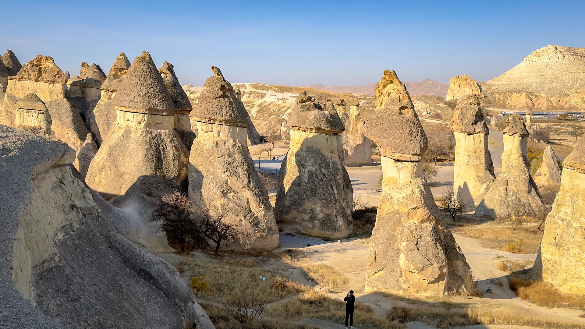
Paşabağ, or Monks Valley, is one of the best places to see the classic form of Cappadocia’s fairy chimneys.
Tall volcanic pillars rise beneath resistant cap rocks, while some formations develop double or multiple crowns. The concentration and accessibility of these formations make Paşabağ particularly useful for understanding the geological process described earlier in this guide.
It is also one of the easiest major fairy-chimney areas to experience without committing to a long hike.
Paths lead between the formations, allowing visitors to see the difference between isolated pillars, clustered chimneys and larger eroded rock masses at close range.
For travellers with limited time who want one strong introduction to Cappadocia’s classic fairy-chimney landscape, Paşabağ is one of the clearest choices.
Paşabağ and nearby Zelve are currently administered together as the Zelve–Paşabağlar Archaeological Site. Because opening hours and ticket arrangements can change, check the official museum information before visiting rather than relying on fixed prices or seasonal schedules in older travel guides.
Zelve: Best for Fairy Chimneys and Rock-Cut Settlement Together
Zelve provides a very different experience.
The site extends through three valleys where fairy chimneys, cliffs and larger volcanic formations are combined with houses, churches, tunnels and other rock-cut spaces.
Turkey’s Ministry of Culture and Tourism describes Zelve as one of the areas where fairy chimneys are most densely concentrated and records its long history as a settlement and religious centre.
This makes Zelve particularly valuable for visitors who want to understand the connection between natural landscape and human adaptation.
Paşabağ shows the geology very clearly.
Zelve shows what happened when communities began living within that geology.
The walking route is longer than simply stopping at a panoramic viewpoint, but it remains manageable for most visitors who are comfortable with natural paths, slopes and occasional steps.
If you have time for both Paşabağ and Zelve, they complement one another extremely well.
Travellers who want to combine Cappadocia’s hiking landscapes with its classic fairy-chimney sites can experience both Paşabağ and Zelve within the Cappadocia Hiking Tour • Valleys & Local Experiences. After several days focused on Ihlara Valley, Red Valley, Swords Valley, Görkündere and Avla Canyon, the final day shifts toward Paşabağ and Zelve, connecting the region’s walking landscapes with some of its clearest examples of fairy chimneys and rock-cut settlement.
Devrent Valley: Best for Natural Rock Shapes
Devrent Valley, often called Imagination Valley, is one of the easiest places to appreciate Cappadocia as a purely erosional landscape.
Unlike Zelve, it is not primarily known for churches or a historic rock-cut settlement.
The attraction is the rock itself.
Irregular formations resemble animals and familiar objects depending on the viewing angle, with the well-known camel-shaped formation becoming the valley’s most recognisable example.
Most visitors can appreciate Devrent from the viewpoints and short walking areas without undertaking a substantial hike.
This makes it particularly useful as a shorter landscape stop between larger sites.
Do not approach it expecting the classic mushroom-shaped fairy chimneys of Paşabağ.
Its value lies in showing how much variety the same volcanic landscape can produce.

Love Valley: Best for Tall Vertical Formations
Love Valley is distinguished by some of Cappadocia’s tallest and most strongly vertical rock formations.
There are two different ways to experience it.
The panoramic viewpoint provides a broad view across the valley with very little walking.
Descending into the valley creates a much stronger sense of scale because the formations rise directly from the trail around you.
Visitors who enjoy hiking can continue further through the valley, while travellers with limited time can use the viewpoint as a shorter stop.
If photography and dramatic vertical formations are the priority, Love Valley provides a perspective quite different from Paşabağ or Zelve.

Red and Rose Valleys: Best for Hiking and Changing Light
Red Valley and Rose Valley are not simply collections of isolated fairy chimneys.
Their appeal comes from a larger erosional landscape of coloured ridges, cones, cliffs and rock-cut spaces.
These valleys are particularly rewarding on foot.
Walking routes pass through volcanic formations, vineyards, cave openings and historic rock-cut churches while the colour of the landscape changes gradually with the light.
Late afternoon is especially effective because the lower sun strengthens the reds, pinks and shadows already present within the volcanic layers.
For travellers who want to experience Cappadocia through hiking rather than a sequence of roadside stops, Red and Rose valleys are among the strongest choices.
Which Valley Is Best for You?
There is no single best fairy-chimney valley.
The better question is what you want to experience.
For classic capped fairy chimneys: Paşabağ
For geology combined with historic settlement: Zelve
For unusual natural rock shapes: Devrent Valley
For tall vertical formations and panoramic views: Love Valley
For hiking, colour and sunset landscapes: Red and Rose Valleys
Seeing two or three contrasting landscapes usually provides a better understanding of Cappadocia than visiting several locations that offer essentially the same experience.
For a wider comparison of the region’s hiking routes, landscapes and valley characteristics, continue with our Valleys of Cappadocia guide.
How Much Walking Is Involved?
The amount of walking varies considerably.
Paşabağ can be explored through relatively short walks between the formations.
Devrent can be appreciated largely from short walking areas and viewpoints.
Zelve requires more movement through a larger archaeological landscape, including slopes and uneven surfaces.
Love Valley can be either a short panoramic stop or a longer valley walk.
Red and Rose valleys are best suited to visitors prepared for genuine hiking on natural volcanic terrain.
Across Cappadocia, trails can include loose gravel, uneven rock, steep sections and exposed surfaces.
Comfortable walking shoes with good grip are considerably more useful than conventional city footwear.
During warmer months, carrying water and avoiding the strongest afternoon heat becomes particularly important.
Can You See Several Fairy Chimney Valleys in One Day?
Yes, but trying to hike every major valley in one day is unrealistic.
A well-planned sightseeing day can comfortably combine several contrasting locations because Paşabağ, Zelve, Devrent and many panoramic viewpoints are relatively close to one another.
A stronger itinerary might combine:
Paşabağ → Zelve → Devrent Valley → panoramic valley viewpoint
rather than attempting long hikes in every location.
If Red and Rose valleys are part of the plan, it often makes more sense to reserve enough time for a proper walk rather than reduce them to another short photo stop.
Our Highlights of Cappadocia Tour is designed around several of the region’s defining landscapes and cultural sites for travellers who prefer to explore them within a privately guided itinerary.
Fairy Chimneys From Above or From the Ground?
The two perspectives reveal different things.
From the ground, you understand scale.
You can walk between the formations, examine layers of volcanic rock and see where people carved rooms, churches and dovecotes into the landscape.
From a hot air balloon, the individual formations become part of a much larger system of valleys, ridges and volcanic plateaus.
Neither perspective replaces the other.
For travellers considering the aerial experience, our Cappadocia Hot Air Balloon page explains how balloon flights work and what to expect before booking.
The strongest understanding of Cappadocia usually comes from combining both perspectives: seeing the landscape as a whole from above and then exploring selected valleys on foot.
A Landscape Shaped by Nature and People
The fairy chimneys of Cappadocia are remarkable geological formations, but geology alone does not explain why the region became such an unusual cultural landscape.
Over centuries, people adapted cliffs, cones and valleys for very different purposes.
They carved homes into the rock.
They created churches and monasteries.
They built dovecotes above agricultural land.
They excavated storage rooms, wine presses and working spaces.
And they cultivated vineyards and orchards between the same volcanic formations that visitors come to photograph today.
UNESCO describes Cappadocia as a landscape in which natural erosion and human settlement became closely interconnected, with rock-hewn churches, dwellings, villages and underground settlements developing directly within the volcanic terrain.
The fairy chimneys are therefore not simply scenery surrounding Cappadocian history.
They are part of the material from which that history was made.
Churches Carved Into the Volcanic Rock
Among the most important examples of this human adaptation are Cappadocia’s rock-cut churches.
Christian communities created sanctuaries, chapels and monastic spaces within the volcanic formations, particularly during the Byzantine period.
The soft rock allowed interiors to be excavated directly into cliffs and cones, while walls and ceilings could then be shaped, plastered and decorated.
Some interiors remained architecturally simple.
Others reproduced elements familiar from conventional church architecture despite being carved rather than constructed.
The density and artistic quality of Cappadocia’s rock-hewn sanctuaries are among the principal reasons UNESCO recognises the region as internationally significant.
For travellers who want to understand this religious layer in greater depth, our Göreme Open Air Museum guide explores one of the most important concentrations of Byzantine rock-cut churches in Cappadocia.
Dovecotes Were Part of the Working Landscape
Small openings cut high into valley walls can easily be mistaken for ordinary caves.
Many are dovecotes, spaces created specifically for pigeons.
They were not decorative curiosities.
Dovecotes formed part of Cappadocia’s agricultural landscape.
Academic research on Byzantine agricultural activity in the region records dovecotes alongside wine presses, mills, ovens, apiaries and other utilitarian installations within rock-cut complexes.
Pigeon manure was valued as fertiliser and became connected with the cultivation of vineyards and other crops. Ethnographic research in Cappadocia has documented the continuing relationship between dovecotes, pigeons, vineyards and local agricultural practice.
This gives the holes visible across many valley walls a very different meaning.
They belonged to an agricultural system.
Vineyards and Wine in the Valleys
Grapes have long been part of Cappadocia’s agricultural landscape.
Rock-cut complexes throughout the region preserve spaces associated with grape processing and wine production, while archaeological research identifies wine presses among the agricultural installations surviving from Byzantine Cappadocia.
The valleys also provided conditions suitable for vineyards.
Rocky volcanic soils, dry summers and the sheltered topography of individual valleys became part of a long tradition of grape cultivation that continues in Cappadocia today.
This relationship is particularly visible when hiking.
A trail can pass from eroded volcanic cliffs into cultivated vines, orchards, dovecotes and rock-cut rooms within a short distance.
The landscape alternates continuously between what nature formed and what people adapted.
Orchards, Storage and Everyday Life
Cappadocia’s valleys were also working environments.
Apricots, grapes and other crops were grown around settlements, while carved spaces could be used for storage and agricultural processing.
Rock-cut rooms provided useful environments for keeping food because the surrounding volcanic material moderated rapid temperature changes.
The result was a landscape in which geology supported several stages of everyday life:
cultivation → processing → storage → habitation
This is important because tourism can make Cappadocia appear as though the valleys were created primarily to be viewed.
Historically, they were lived and worked in.
Why Rock-Cut Architecture and Agriculture Belong Together
The same geological conditions made both possible.
Soft volcanic rock could be carved into rooms.
Valley floors and slopes could support agriculture.
Rock faces could contain dovecotes.
Excavated spaces could hold crops, tools or wine-making installations.
The landscape therefore did not divide neatly into “nature” and “architecture”.
A single formation could belong to both.
This relationship helps explain why UNESCO describes Cappadocia not simply as a geological site or archaeological collection, but as an exceptional example of traditional human settlement interacting with dramatic natural landforms.
Fairy Chimneys Beyond the Viewpoints
Panoramic viewpoints are useful for understanding the scale of Cappadocia.
But they reveal only one dimension of the landscape.
Walking through a valley brings the relationship between people and geology much closer.
At ground level, you begin to notice:
- carved doorways above the trail
- small churches hidden in rock faces
- dovecotes high along cliffs
- vineyards between eroded formations
- old storage spaces
- orchards beside walking paths
- traces of settlements that are almost invisible from a distant viewpoint
These details are often what transform a scenic visit into an understanding of how Cappadocia actually functioned.
What a Hot Air Balloon Shows
A hot air balloon provides the opposite perspective.
From above, individual fairy chimneys become part of a much larger topographic system.
Valleys connect with ridges.
Settlements occupy natural openings between volcanic formations.
Agricultural plots appear between cliffs and plateaus.
Rock-cut architecture becomes embedded within a landscape rather than standing out as a collection of separate monuments.
This aerial perspective is especially effective for understanding scale and geography.
But it cannot reveal many of the details that become visible on foot.
What Walking Through the Valleys Shows
Walking reveals human scale.
A formation that appears small from a panoramic viewpoint can rise several storeys beside the trail.
A dark opening in a cliff becomes a church, dovecote or former room.
Agricultural terraces and vineyards become visible.
The relationship between natural surfaces and carved architecture becomes much easier to understand.
This is why hiking and aerial views should not be treated as competing ways to experience Cappadocia.
They answer different questions.
From above: How does the landscape fit together?
On foot: How did people live within it?
Why This Cultural Landscape Matters
Cappadocia would still be geologically remarkable if nobody had ever carved into its rocks.
And its churches, houses and agricultural structures would still be historically interesting without the surrounding fairy chimneys.
What makes the region exceptional is that the two cannot easily be separated.
Volcanic activity created the material.
Erosion created the landscape.
People learned how to inhabit it.
UNESCO’s World Heritage assessment explicitly recognises this interaction between natural formations and human settlement as one of Cappadocia’s defining qualities.
The fairy chimneys therefore tell two stories at once.
One unfolds across millions of years of geology.
The other belongs to the generations of people who turned that geology into places to live, worship, work and cultivate the land.
Are There Fairy Chimneys Outside Cappadocia?
Yes.
Similar erosional landforms occur in many parts of the world and are often described as hoodoos, earth pyramids, pinnacles or fairy chimneys, depending on their geology and local terminology.
The U.S. National Park Service notes that hoodoos occur on every continent, with Bryce Canyon National Park in Utah containing the largest concentration known anywhere in the world. (nps.gov)
But similarity in shape does not mean these landscapes formed from the same type of rock.
That distinction is important when comparing them with Cappadocia.
Cappadocia and Bryce Canyon: Similar Shapes, Different Geology
Bryce Canyon provides one of the clearest comparisons.
Both landscapes contain tall pillars and irregular rock formations produced through differential erosion.
But the geological materials are very different.
Bryce Canyon’s hoodoos developed largely within the Claron Formation, composed of sedimentary rocks including limestone and mudstone deposited in an ancient lake and floodplain environment. Frost weathering, runoff and chemical erosion then helped sculpt those rocks into the columns seen today. (nps.gov)
Cappadocia developed from a different geological history.
Its fairy chimneys were carved primarily from volcanic ignimbrites and associated deposits laid down during repeated eruptions across the Cappadocian Volcanic Province. Subsequent uplift and erosion transformed those deposits into valleys, cones and the formations known as fairy chimneys. (iugs-geoheritage.org)
The visual result can sometimes appear similar.
The geological story is not.
Does Every Hoodoo Have a Cap Rock?
No.
The popular image of a hoodoo or fairy chimney often shows a narrow pillar supporting a harder stone cap, but these formations exist in many shapes and stages of erosion.
At Bryce Canyon, differential weathering can leave resistant layers protecting softer rock beneath, while frost action and runoff play particularly important roles in shaping the landscape. (nps.gov)
Cappadocia also contains classic capped forms, particularly around Paşabağ, but many of its formations are cones, pinnacles, ridges or irregular rock masses without a clearly defined stone hat.
The term therefore describes a broader family of erosional forms rather than one exact silhouette.
What Makes Cappadocia Different?
Cappadocia’s importance does not come from claiming that fairy chimneys exist nowhere else.
They do.
What distinguishes Cappadocia is the scale of the volcanic landscape and the extraordinary extent to which people inhabited and transformed it.
The International Union of Geological Sciences identifies the Cappadocian ignimbrite sequence as an important geoheritage landscape and specifically notes the presence of numerous rock-cut settlements carved into the same volcanic formations that developed fairy chimneys. (iugs-geoheritage.org)
Across Cappadocia, erosion created the rock formations.
People then carved that rock into:
- homes
- churches and monasteries
- storage spaces
- dovecotes
- agricultural installations
- entire settlements
This is the distinction that matters most.
A Geological Landscape Became a Cultural Landscape
At Bryce Canyon, the hoodoos are principally experienced as natural geological formations.
In Cappadocia, geology became part of architecture and settlement.
A fairy chimney might contain rooms.
A cliff could hold a Byzantine church.
A valley wall could be filled with dovecotes.
Larger volcanic formations could become villages, monasteries or defensive spaces.
The geological landscape therefore became a cultural landscape.
This relationship between volcanic landforms and human use is one of the reasons Cappadocia cannot be understood simply as Turkey’s version of another hoodoo landscape.
Cappadocia’s Rock Was Part of Everyday Life
The human relationship with the landscape was not limited to monumental churches or famous archaeological sites.
Rock-cut spaces were also connected with ordinary life.
People stored food.
Kept animals.
Processed grapes.
Created dovecotes.
Expanded homes.
And adapted naturally formed rock to changing needs over generations.
This continuity between dramatic geology and practical everyday use is one of Cappadocia’s most distinctive characteristics.
It is also why seeing the landscape only from panoramic viewpoints provides an incomplete picture.
Why Comparing Cappadocia With Other Hoodoo Landscapes Is Useful
Comparison helps clarify what is genuinely distinctive.
Cappadocia does not need to be described as the only place on Earth with fairy chimneys to be exceptional.
Bryce Canyon demonstrates that spectacular pillars can emerge from a very different sedimentary landscape through its own combination of weathering and erosion. The National Park Service identifies Bryce as having the world’s greatest concentration of hoodoos. (nps.gov)
Cappadocia’s distinction lies elsewhere.
Its fairy chimneys belong to a volcanic sequence several hundred metres thick, shaped from Miocene ignimbrites under particular geological and topographic conditions. The same rocks were then excavated on an extraordinary scale for human settlement and cultural use. (iugs-geoheritage.org)
The result is not simply an unusual geological landscape.
It is a place where geological and human history became physically inseparable.
Why This Matters Before You Visit
Knowing that similar rock pillars exist elsewhere does not make Cappadocia less remarkable.
It makes the reason for visiting clearer.
You are not travelling only to see unusual stone formations.
You are entering a landscape where volcanic history, erosion, Byzantine churches, cave dwellings, vineyards, villages and modern life occupy the same terrain.
For a broader explanation of what makes the region worth experiencing beyond its most famous photographs, continue with our Why Visit Cappadocia guide.
Planning Your Fairy Chimney Visit
The fairy chimneys can be seen throughout the year, but the experience changes considerably with season, time of day and the amount of walking you plan to do.
A short viewpoint stop requires very little preparation.
A full valley hike is different.
Choosing where to go should therefore begin with how you want to experience the landscape rather than with a checklist of famous formations.
What Is the Best Season to See the Fairy Chimneys?
Spring and autumn generally provide the most comfortable conditions for walking through Cappadocia’s valleys.
Days are usually milder than in midsummer, making longer hikes through places such as Red, Rose and Love valleys more comfortable.
Summer offers long daylight hours and generally dry conditions, but exposed trails can become hot around the middle of the day. Starting earlier in the morning or planning longer walks for later in the afternoon is usually more comfortable.
Winter creates a completely different landscape.
Cold weather and occasional snow can transform the fairy chimneys visually, but trails may be wet, icy or muddy and daylight hours are shorter.
There is therefore no single season when the formations themselves are “best”.
The better season depends on whether your priority is hiking, photography, quieter landscapes or warmer weather.
What Is the Best Time of Day?
Morning and late afternoon generally provide the most interesting light.
Early light creates stronger shadows across the formations and works particularly well around Göreme and the balloon-flight areas.
Late afternoon is especially effective in Red and Rose valleys, where low-angle sunlight intensifies the texture and existing colour differences within the volcanic rock.
Midday is still perfectly suitable for visiting archaeological sites and shorter viewpoints, but stronger overhead light can make the landscape appear flatter in photographs.
If you are hiking during summer, light and temperature point toward the same solution:
avoid planning the longest exposed walks for the hottest part of the afternoon.
Do You Need a Guide to See the Fairy Chimneys?
No.
Many of Cappadocia’s principal viewpoints and valleys can be explored independently.
Travellers with their own vehicle or reliable transportation can combine places such as Paşabağ, Zelve, Devrent and panoramic viewpoints without joining an organised tour.
A guide becomes more valuable when the goal is not simply to locate the formations but to understand them.
The differences between volcanic layers, the relationship between rock-cut settlements and geology, the function of dovecotes and agricultural spaces, and the historical context of churches or settlements are not always obvious from the landscape alone.
The question is therefore less “Can I visit independently?” and more “How much interpretation do I want?”
How Many Fairy Chimney Areas Should You Visit?
For most first-time visitors, two or three contrasting locations are more useful than trying to stop at every viewpoint.
For example:
Paşabağ provides the classic capped fairy chimney.
Zelve connects geology with rock-cut settlement.
Red and Rose valleys provide hiking and coloured volcanic landscapes.
Another combination might substitute Devrent or Love Valley depending on whether unusual natural forms or tall vertical formations are the priority.
The aim should be contrast, not quantity.
Once several locations begin showing the same thing from slightly different roadside viewpoints, additional stops add less value than spending more time walking through one valley.
Respecting a Landscape That Is Still Eroding
Fairy chimneys are not indestructible rock monuments.
They are products of erosion, and that erosion continues.
UNESCO describes the Cappadocian World Heritage landscape as vulnerable to both natural erosion and the effects of intensive tourism. Rock-cut churches and other cultural features face particular risks when natural deterioration is combined with visitor pressure and development.
For visitors, responsible behaviour is straightforward.
Stay on established routes where they exist.
Do not carve names or markings into the soft volcanic rock.
Avoid climbing fragile formations unless a route is specifically intended for access.
Do not enter closed rock-cut spaces.
And treat historic dovecotes, churches and carved rooms as cultural heritage rather than as empty caves.
The same softness that allowed generations to carve Cappadocia’s architecture also makes that architecture vulnerable.
Fairy Chimneys Are Better Experienced Than Collected
It is easy to turn Cappadocia into a sequence of stops:
Paşabağ.
Zelve.
Devrent.
Love Valley.
Sunset viewpoint.
But the landscape makes more sense when enough time is allowed to understand the differences between them.
Walk beneath one formation rather than seeing every valley from above.
Look closely at the rock layers.
Notice where people carved rooms into cliffs.
Find dovecotes above vineyards.
Compare a capped chimney at Paşabağ with the larger eroded forms at Zelve.
The objective is not to collect the largest possible number of fairy-chimney photographs.
It is to understand why the same volcanic landscape looks and functions differently from one valley to another.
Exploring the Fairy Chimneys with Adventus Travel
Fairy chimneys are easy to photograph but more rewarding when placed within the wider story of Cappadocia.
A privately guided visit can connect the formations with the volcanic landscape, rock-cut settlements, Byzantine heritage, agricultural traditions and communities that developed around them rather than treating each viewpoint as an isolated attraction.
For travellers who want enough time to combine Cappadocia’s principal landscapes with its underground and cultural heritage, our 3 Days Cappadocia Tour provides a broader privately guided framework while allowing the itinerary to be adapted around individual interests and walking preferences.
Frequently Asked Questions About the Fairy Chimneys of Cappadocia
How were the fairy chimneys of Cappadocia formed?
The fairy chimneys developed through erosion of volcanic deposits laid down by repeated eruptions millions of years ago.
Softer volcanic rock eroded more quickly than more resistant layers, gradually creating cones, pillars and capped formations across Cappadocia.
Are Cappadocia’s fairy chimneys man-made?
No.
The formations themselves are natural geological features.
People later carved homes, churches, dovecotes, storage spaces and other rooms into many of Cappadocia’s volcanic cliffs and rock formations.
Where is the best place to see classic fairy chimneys?
Paşabağ is one of the clearest places to see the classic capped, mushroom-like form commonly associated with Cappadocia.
Other valleys provide very different shapes, so seeing more than one area gives a better understanding of the landscape.
Can you go inside the fairy chimneys?
Some rock formations contain accessible historic rooms, churches or adapted spaces, but not every fairy chimney can or should be entered.
Access depends on the site, conservation condition and current visitor management.
Can you see the fairy chimneys without taking a hot air balloon?
Yes.
Walking through the valleys is one of the best ways to understand their scale, geology and relationship with rock-cut architecture.
A balloon provides a different aerial perspective but is not necessary to experience the fairy chimneys themselves.
Can you visit the fairy chimneys independently?
Yes.
Many major valleys and viewpoints can be reached independently by car, taxi or on foot depending on the location.
Guided visits are most useful for travellers who want geological, historical and cultural interpretation rather than transportation alone.
Can you visit several fairy chimney valleys in one day?
Yes.
Several major sites lie relatively close together, and a sightseeing day can combine contrasting locations such as Paşabağ, Zelve and Devrent.
Long hikes through multiple valleys should be planned separately rather than compressed into the same day.
Are the fairy chimneys part of a UNESCO World Heritage Site?
Many of Cappadocia’s most important formations lie within the Göreme National Park and the Rock Sites of Cappadocia World Heritage property.
UNESCO recognises both the spectacular erosional landscape and its exceptional relationship with rock-cut settlements and cultural heritage.
WRITTEN BY

Nisa Buket Dağdelen
Operations Director & Tour Guide
LinkedIn Profile

Hüseyin Pekgöz
Founder & Managing Partner
LinkedIn Profile
Adventus Travel Company


