
Cappadocia is famous for what rises above the ground: fairy chimneys, volcanic valleys, rock-cut churches and settlements carved into cliffs. Yet some of the region’s most remarkable architecture developed in the opposite direction, descending beneath villages and agricultural land into networks of rooms, passages, shafts and protected spaces.
The underground cities of Cappadocia form one of the largest concentrations of subterranean settlements in Anatolia. Kaymaklı and Derinkuyu are the best-known examples, but they belong to a much wider regional tradition extending across modern Nevşehir, Aksaray, Kayseri and Niğde.
These complexes were not identical. Some descend through multiple levels, while others spread more horizontally. Their documented spaces include stables, storage rooms, kitchens, wineries, churches, wells, ventilation shafts and defensive passages. Their functions also changed over time, making it misleading to imagine every underground city as a single-purpose refuge built by one civilization.
For the wider geological, historical and practical context of the region, see our Cappadocia Travel Guide.
This guide looks beyond Derinkuyu and Kaymaklı to examine the broader underground landscape of Cappadocia: what these places actually were, how many have been identified, why they could be carved into the region’s volcanic rock, when they developed, how people used them and how the major underground settlements differ from one another.
Were Cappadocia’s Underground Cities Really Cities?
The term underground city is useful because it is widely understood by travellers, but archaeologically it can be misleading.
These were not cities in the modern sense, with entire populations permanently living below ground and carrying out all aspects of daily life underground.
An older archaeological survey of Cappadocia already raised this problem, noting that the number of inhabitants in these complexes could not be established reliably and suggesting that underground settlement was a more accurate term for many of them.
Modern specialist research has moved even further in this direction. A 2026 archaeological study by Ali Yamaç and Ezgi Tok uses the term underground shelters and interprets many of Cappadocia’s larger subterranean systems primarily as defensive structures associated with periods of insecurity.
The terminology matters because the architecture itself suggests several overlapping functions.
Some underground spaces were used for: storage, wine and food production, animal shelter, religious activity, water access, communication, and defence.
During periods of danger, deeper and more secure sections could support communities below ground. At other times, parts of the same underground systems could continue functioning as cellars, stables or storage areas connected with normal life on the surface.
It is therefore more accurate to understand Cappadocia’s underground cities as subterranean extensions of surface settlements, whose roles could change according to period and circumstance.

How Many Underground Cities Are There in Cappadocia?
There is no single definitive number.
Turkish museum authorities currently estimate that approximately 150 to 200 underground settlements of varying sizes exist across the Cappadocia region. The official descriptions of both Kaymaklı and Özkonak use this range and note that additional subterranean settlements may still be identified.
This estimate is remarkably consistent with the older archaeological source you provided, which also referred to approximately 150 to 200 known underground settlements across Cappadocia.
More recent specialist work indicates that the number may already be higher. The 2026 study Underground Shelters of Cappadocia, Turkey provides an inventory of the subterranean shelters identified so far across the region and describes the network as exceeding 200 documented examples.
The difference does not mean one source is necessarily wrong.
It reflects the difficulty of defining and counting these sites.
Some are extensive multi-level complexes.
Others consist of smaller subterranean systems associated with villages.
Many remain only partially explored.
Some passages have collapsed.
Others are known locally but have never been prepared for visitors.
For travellers, the most important distinction is therefore between identified underground settlements and underground cities that are safely accessible today.
Only a small proportion of the regional network is open through established visitor routes.
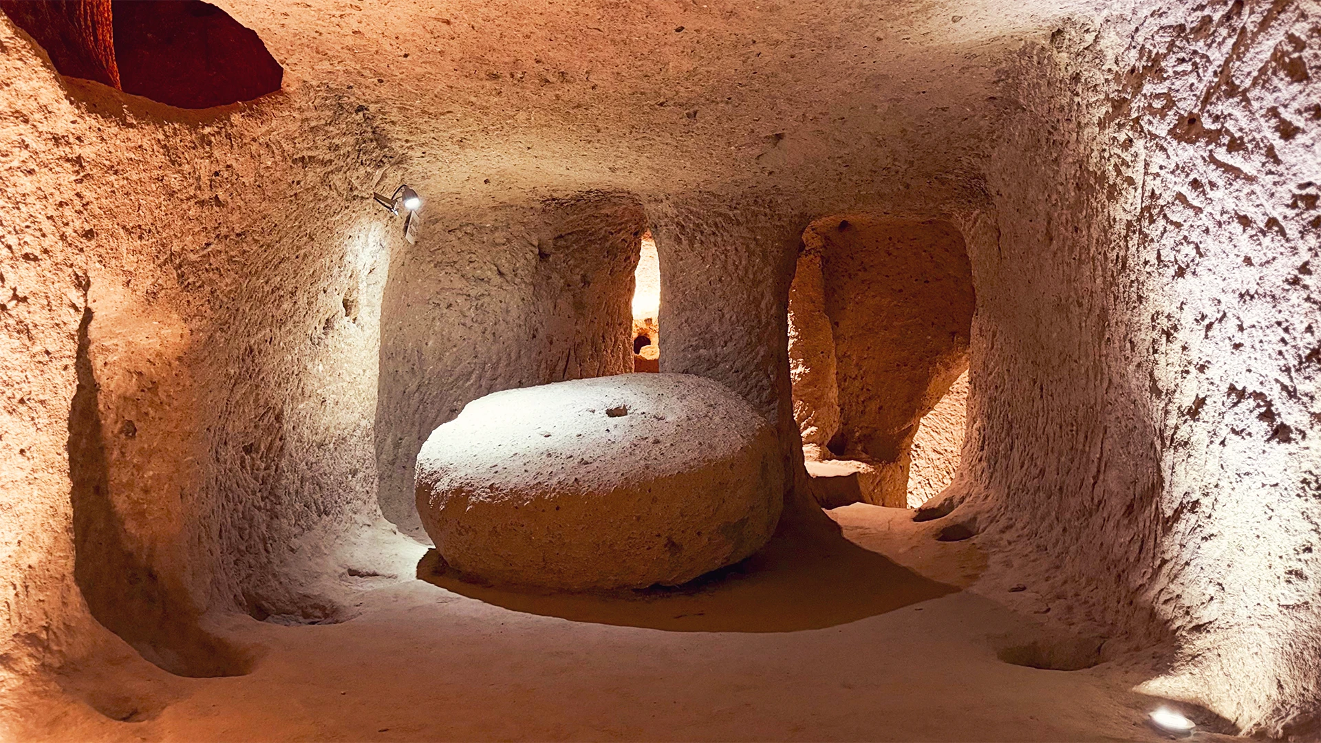
Continue Exploring Cappadocia
Plan Your Cappadocia Trip
- Cappadocia Travel Guide
- 10 Unforgettable Things to Do in Cappadocia Beyond Balloons
- Cappadocia Cave Hotels: History, Authenticity & How to Choose
Explore Cappadocia’s Underground Heritage
Suggested Private Tours
Cappadocia’s Underground Landscape Extends Beyond Derinkuyu and Kaymaklı
Derinkuyu and Kaymaklı dominate international awareness, partly because both are included within the UNESCO World Heritage property of Göreme National Park and the Rock Sites of Cappadocia. UNESCO specifically identifies them as subterranean towns within the wider rock-cut cultural landscape of the region.
But concentrating only on these two sites creates a distorted picture.
Important underground settlements also include:
Özkonak
Mazı
Tatlarin
Saratlı Kırkgöz
Saint Mercurius
Gaziemir
Çukurören
as well as subterranean sites around Ağırnas and other parts of Kayseri, and additional complexes toward Niğde and southern Cappadocia.
These sites matter because they reveal regional variation.
Özkonak preserves unusual communication and defensive features.
Tatlarin contains spaces that have led archaeologists to consider monastic or military functions.
Gaziemir presents an architectural arrangement interpreted more like a subterranean caravan complex than a conventional refuge.
Other sites emphasize livestock, storage, production or religious use.
The underground landscape of Cappadocia was therefore not a network of identical cities repeated beneath different villages.
It was an adaptable architectural tradition.

Why Could Cappadocia Be Carved Underground?
The underground settlements are possible because of the same geological history that created Cappadocia’s surface landscape.
The region developed within a volcanic environment shaped by eruptions associated with major volcanic centres including Mount Erciyes and Hasan Dağı. Layers of volcanic material accumulated across Central Anatolia and were later reshaped by erosion.
UNESCO describes Cappadocia as a volcanic landscape sculpted into ridges, valleys and pinnacles and then extensively modified by human occupation through rock-hewn dwellings, churches, villages and subterranean towns.
The older archaeological source also emphasizes that Cappadocia contains several volcanic materials of different hardness, including tuff and ignimbrite, whose properties influenced both natural erosion and human excavation.
Certain layers could be excavated with relatively simple tools while remaining sufficiently stable after carving.
That created an unusual form of architecture.
Instead of transporting stone and constructing walls upward, people could remove material from the existing rock.
A room could be enlarged.
Another passage could be added.
A lower level could be excavated.
Vertical shafts could connect spaces at different depths.
The architecture developed through subtraction rather than construction.
This same relationship between geology and human adaptation can be seen throughout Cappadocia, from rock-cut houses and churches to the Fairy Chimneys of Cappadocia.

The Underground Cities Were Part of a Larger Rock-Cut Culture
Cappadocia’s subterranean architecture should not be treated as an isolated technological invention.
People throughout the region repeatedly adapted natural rock to human needs.
Cliffs became houses and churches.
Valley walls contained monasteries, dovecotes and storage rooms.
Rock masses were hollowed out to create domestic and religious spaces.
Underground settlements extended the same architectural logic beneath the surface.
The older Cappadocia study divides the region’s rock settlements broadly into cliff settlements and underground settlements, demonstrating how both forms belonged to the same wider tradition of carving rather than conventional masonry construction.
This continuity is important.
The question is not simply why people suddenly decided to build cities underground.
A better question is:
Why did communities already accustomed to rock-cut architecture begin extending increasingly complex protected spaces beneath their settlements?
Answering that requires confronting one of the most debated questions in Cappadocian archaeology:
How Old Are the Underground Cities of Cappadocia?
There is no simple answer.
Different sources have attributed their origins to prehistoric communities, the Hittites, Roman-period populations and Byzantine Christians.
Some of those interpretations may contain elements of truth, but they do not all refer to the same phase of construction.
The next section examines this dating debate, separating possible early rock-cut activity from the much clearer evidence for large-scale defensive use and expansion during the Byzantine period.
How Old Are the Underground Cities of Cappadocia?
The age of Cappadocia’s underground cities is one of the most debated questions surrounding them.
There is no archaeological evidence showing that all of the underground settlements were created during a single period. The problem is compounded by the nature of rock-cut architecture itself. Excavating a room removes the material that might otherwise preserve a construction sequence, and spaces could be enlarged, altered or reused repeatedly over centuries.
This makes it difficult to assign one date to an entire underground complex.
Older interpretations have connected parts of Cappadocia’s subterranean tradition with prehistoric communities and the Hittites. Roman-period occupation and Early Christian use have also been proposed, while the strongest surviving architectural evidence in many of the larger complexes points toward substantial development during the Byzantine period.
The archaeological source used for this guide already recognized this uncertainty decades ago. It discussed prehistoric settlement, Hittite rock-cut passages, Roman rock tombs and later Christian occupation, while acknowledging that direct evidence connecting the earliest populations with the large underground complexes remained limited.
Recent specialist research has made this distinction even more important.
The 2026 study Underground Shelters of Cappadocia, Turkey identifies dating as one of the major unresolved issues surrounding these structures and proposes that many of the large defensive underground shelters were constructed or substantially developed between the 7th and 11th centuries AD, particularly in response to Arab raids into Byzantine Anatolia.
This does not necessarily mean that every carved space beneath Cappadocia began in that period.
It means that the large, organized defensive systems visible today may be considerably later than some of the earliest rock-cut activity in the region.
Were the Underground Cities Built by the Hittites?
The Hittite theory has a long history and remains common in both tourism literature and some official descriptions.
The Turkish Museums authority currently states that Kaymaklı has origins extending to around 3000 BCE, attributes an early phase to the Hittites and describes later enlargement during Roman and Byzantine periods.
There are reasons why an early origin has been considered plausible.
Cappadocia and the surrounding Central Anatolian landscape were occupied during the Bronze Age.
Hittite communities were familiar with rock-cut construction.
Defensive underground passages, often referred to as poterns, are known from Hittite fortifications elsewhere in Anatolia.
The older archaeological study of Cappadocia also considered whether this tradition could have contributed to the earliest subterranean architecture in the region. At the same time, it noted the absence of clear archaeological material directly demonstrating that the major Cappadocian underground cities themselves were Hittite constructions.
That distinction should not be lost.
A civilization possessing the technical knowledge to excavate rock does not automatically prove that it constructed a particular underground settlement.
For this reason, it is safer to describe Hittite involvement as a possible early phase in the development of Cappadocia’s subterranean tradition, rather than presenting the Hittites as the confirmed builders of Derinkuyu, Kaymaklı or the wider underground-city network.
What Happened During the Roman and Early Christian Periods?
Rock-cut architecture continued to develop across Cappadocia during the Roman period.
Tombs, dwellings and other spaces were excavated into the region’s rock, demonstrating that carving had become an established architectural practice.
Christian communities later transformed Cappadocia even more extensively.
From Late Antiquity onward, rock-cut churches, monasteries, cells and settlements became increasingly prominent. UNESCO describes Cappadocia’s traditional rock-cut habitat as extending back to at least the 4th century AD, when early Christian monastic communities were already occupying spaces carved into the landscape.
This period is important for the underground cities for two reasons.
First, communities already possessed considerable experience in creating complex rock-cut architecture.
Second, religious and political conditions would eventually make protected subterranean spaces increasingly useful.
The transition was probably gradual.
Existing underground rooms could be enlarged.
Storage areas could be connected.
Additional levels could be excavated.
Religious spaces could be introduced into complexes that already served practical functions.
The underground settlements visible today may therefore contain architectural phases belonging to very different periods.

Byzantine Cappadocia and the Expansion of Underground Refuge
The clearest historical context for the large underground refuge systems emerges during the Byzantine period.
From the 7th century onward, Central Anatolia was repeatedly affected by warfare between the Byzantine Empire and Arab forces advancing from the southeast.
These were not necessarily permanent occupations of every Cappadocian settlement. Raiding, military movement and regional insecurity could themselves create strong incentives for rural communities to develop places where people, livestock and provisions could temporarily be protected.
UNESCO directly connects the subterranean towns of Kaymaklı and Derinkuyu with this period, explaining that communities formed troglodyte villages and underground towns that served as refuges against Arab incursions.
The 2026 specialist study reaches a similar conclusion from a more focused archaeological perspective, proposing the 7th to 11th centuries as the principal construction period for many Cappadocian underground defensive shelters.
This interpretation also helps explain several architectural features found repeatedly across the underground settlements: restricted entrances, narrow corridors, rolling stone doors, controlled passages between levels, ventilation systems, storage rooms, water access, and spaces capable of supporting animals and people.
Together, these features make much more sense as parts of an organized refuge system than as ordinary permanent urban architecture.
There Was Probably No Single Construction Period
The most useful way to understand the chronology is therefore to avoid searching for one founding date.
Cappadocia’s underground settlements were likely cumulative structures.
A smaller subterranean space could begin as storage or a cellar.
It could later be connected with another room.
A deeper level might be excavated.
Defensive doors could be introduced.
A church might be carved during a later Christian phase.
Existing passages could be widened, narrowed or redirected.
Centuries later, villagers might continue using accessible parts for storage even after the defensive function had disappeared.
The underground city we see today may therefore represent the accumulated result of several episodes of excavation and reuse.
This is also why questions such as: “When was Derinkuyu built?” or “Who built Kaymaklı?” do not have reliable one-line answers.
The archaeological question is not simply who began carving.
It is when each underground system reached the scale and organization that allowed it to function as a protected communal refuge.

Why Were the Underground Cities of Cappadocia Used?
Security was probably the most important reason the larger underground systems developed to such an extraordinary scale.
But protection was not their only function.
The architecture reveals a system designed to preserve the essentials of community life during periods when remaining on the surface could become dangerous.
Underground spaces could accommodate: livestock, food and wine, water, storage, food preparation, religious practice, and groups of people moving between protected sections.
This required far more planning than simply excavating a hiding place.
Ventilation had to reach lower levels.
Movement had to remain possible while entrances were defended.
Animals needed access without being taken through the deepest passages.
Food and water needed to remain available.
Different areas had to be separated according to function.
The result was a form of defensive settlement infrastructure closely connected with the villages above it.
Refuge Did Not Mean Permanent Underground Life
The image of thousands of people spending their entire lives beneath Cappadocia is compelling, but there is little reason to interpret the underground cities that way.
Official information for Kaymaklı describes the complex as providing the conditions necessary for a community to live underground temporarily.
That fits the architecture well.
Agriculture required access to the surface.
Vineyards, fields and livestock depended on the surrounding landscape.
Normal trade and communication also occurred above ground.
The underground system became most valuable when those activities were interrupted by danger.
Communities could withdraw below the surface while preserving enough food, water, animals and social structure to remain protected until conditions improved.
Afterward, surface life could resume.
Some underground areas could continue being used as cellars, storerooms or animal spaces even in peaceful periods.
The relationship was therefore not: surface city versus underground city. It was: surface settlement plus an extensive subterranean infrastructure beneath it.
Why Were Entrances Hidden?
Concealment increased the effectiveness of the refuge system.
The older archaeological survey describes underground entrances associated with houses and surface settlements, making them difficult for outsiders to identify immediately.
Once an entrance was discovered, the architecture provided additional layers of protection.
A narrow passage limited how many people could enter at once.
A rolling stone could close a corridor.
Another defensive point could exist deeper inside.
The settlement therefore did not depend on one fortified entrance.
Defence continued inside the underground architecture itself.
This principle is one of the most sophisticated aspects of the Cappadocian systems.
Instead of relying primarily on walls surrounding a settlement, communities could use depth, restricted movement and familiarity with the internal layout as defensive advantages.

Underground Cities Were Designed Around Time
An underground refuge only becomes useful if people can remain inside for more than a few hours.
This explains why the architecture extends beyond passages and defensive doors.
Storage rooms allowed provisions to be accumulated.
Wells and water systems reduced dependence on the surface.
Ventilation shafts made deeper occupation possible.
Stables protected economically important animals.
Wine and food-production spaces supported supplies.
Religious rooms helped communal practices continue.
The underground city was therefore not simply designed to prevent an enemy from entering.
It was designed to give the community time.
Time for a raid to pass.
Time for military movement to shift elsewhere.
Time until returning to the surface became possible.
The engineering of the underground cities becomes much easier to understand when viewed through this objective.
The next section examines exactly how that system worked, including ventilation shafts, wells, rolling stone doors, kitchens, wineries, stables, storage rooms and the vertical organization of daily life beneath Cappadocia.
How Did Cappadocia’s Underground Cities Work?
The underground cities of Cappadocia were not simply collections of rooms connected by tunnels.
Their architecture reflects a practical system in which depth, ventilation, movement, storage and defence were organized together.
The older archaeological study you provided is especially useful here because it describes recurring patterns observed across multiple underground settlements rather than focusing on a single famous site. It notes that different functions were often arranged according to depth, with animals and some production areas closer to the surface and more protected spaces extending further below.
This does not mean every underground city followed exactly the same plan.
Kaymaklı, Derinkuyu, Özkonak, Tatlarin and the other major settlements all developed differently.
But several architectural principles appear repeatedly.
Underground Life Was Organized Vertically
One of the most useful ways to understand Cappadocia’s underground cities is to think vertically.
The upper levels generally had easier access to the surface.
They were therefore better suited to activities that required frequent movement, stronger ventilation or contact with animals.
Deeper levels provided greater protection.
The older archaeological survey observes that stables were commonly positioned near the upper levels, while kitchens, wineries and other working spaces also tended to remain relatively accessible. Storage, protected living areas and religious spaces could extend further into the system.
This arrangement was practical rather than symbolic.
Moving livestock through deep, narrow tunnels would have been difficult.
Smoke and smells from animals or cooking needed ventilation.
Heavy supplies were easier to move when they did not have to pass through several constricted levels.
The underground city therefore functioned through spatial organization according to need.

Why Were Stables Usually Near the Entrance?
Animals were economically important to rural communities.
They provided transport, food, milk, wool and agricultural labour.
Protecting them during periods of danger could therefore be almost as important as protecting people.
At Kaymaklı, official museum documentation places the stable on the first accessible level. The older Cappadocia survey describes the same broader pattern and argues that the upper positioning made it easier to move animals in and out while reducing the need to take them through the lower underground passages.
The stable areas also required stronger airflow.
Keeping animals closer to the surface limited the amount of heat, moisture and smell entering the deeper sections of the settlement.
This is a good example of how apparently simple architectural choices reveal the practical logic behind the underground system.
Kitchens and Food Preparation
Food preparation had to continue even when people remained underground for an extended period.
Kitchens have been identified in several Cappadocian underground settlements.
The older archaeological source notes that kitchens were generally located in upper or intermediate levels and refers to ovens known locally as tandır, a traditional form of earth or clay oven still associated with Anatolian cooking.
The placement again makes practical sense.
Cooking creates heat and smoke.
Areas closer to ventilation routes could manage those effects more effectively than deep enclosed rooms.
Food preparation also needed to remain close to stored provisions and communal spaces.
The result was not one central industrial kitchen.
Individual underground settlements developed different arrangements according to size and layout.
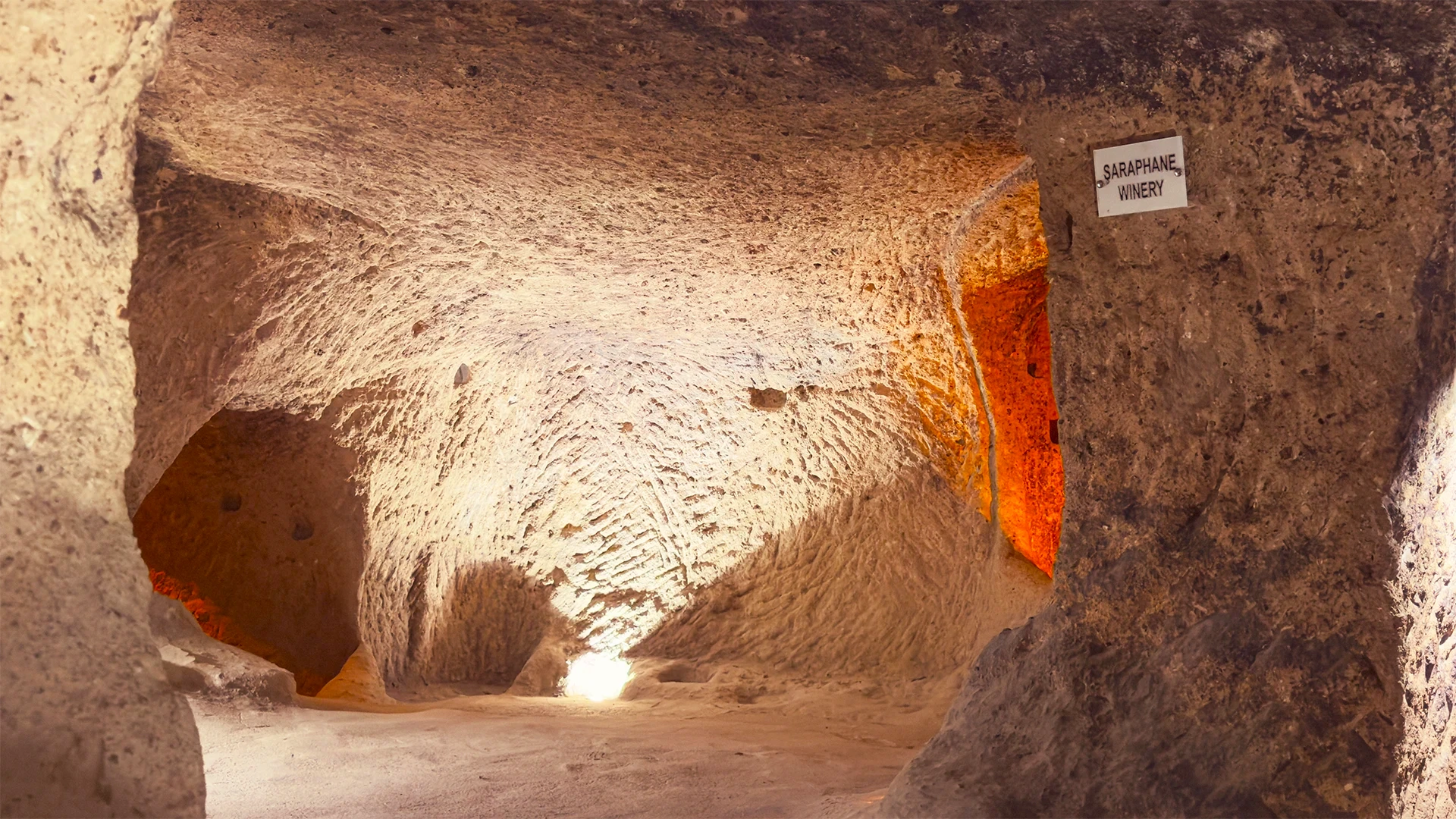
Wineries Show the Connection With Cappadocia’s Agricultural Landscape
Wine-related installations appear frequently within Cappadocia’s underground architecture.
This is particularly important because vineyards have long been part of the region’s agricultural landscape.
The older source describes wine presses and storage areas within the underground settlements and notes that large vessels could be used to store wine and other provisions.
At Kaymaklı, wine-production areas are officially documented alongside kitchens and storage rooms.
These installations remind us that underground architecture was closely connected with agriculture above ground.
Grapes were grown outside.
Wine could be processed or stored below.
The underground environment offered relatively stable temperatures that were useful for storage.
The subterranean city therefore remained economically connected to the landscape surrounding it.
Storage Was Essential
A defensive refuge becomes ineffective very quickly if food cannot be stored.
Large storage areas therefore appear repeatedly across the major underground settlements.
The older survey describes large jars set into or supported within underground rooms and notes the storage of grain, wine and other provisions.
At Kaymaklı, the concentration of storage rooms is one of the most important features of the explored complex.
This does not necessarily mean that every room was filled specifically for periods of attack.
Storage spaces were useful throughout the year.
Grain, wine and preserved foods could remain below ground even when communities were living normally on the surface.
This again demonstrates the dual character of the underground settlements:
everyday infrastructure in peaceful periods and protected refuge during instability.

How Did Ventilation Work?
Ventilation was one of the fundamental requirements of underground architecture.
The larger settlements contain vertical shafts extending through multiple levels.
These shafts allowed fresh air to circulate into deeper spaces while warmer air could move upward through the system.
The older Cappadocia survey also records smaller holes between floors and adjoining rooms that may have helped distribute air and allowed limited communication between different parts of a complex.
At Kaymaklı, many of the accessible rooms are organized around major ventilation shafts.
At Derinkuyu, the scale becomes even more dramatic because one major vertical shaft extends far into the underground system.
This infrastructure had to support: people, animals, oil lamps, cooking, and food-processing activities.
Without carefully planned airflow, the deeper sections would have been far less usable.
Ventilation Shafts Were Part of the Plan
It is tempting to imagine underground cities being expanded randomly as communities needed more space.
The ventilation systems suggest something more organized.
A room could only be excavated safely at depth if air circulation was considered.
The relationship between major shafts and surrounding rooms indicates that at least some phases of construction followed a broader architectural logic.
This does not mean the entire city was designed at once.
Many complexes probably developed gradually.
But later expansion had to remain compatible with the systems already keeping the underground environment functional.
Water Had to Remain Accessible Underground
Water was another critical requirement.
Communities taking refuge below ground could not rely on repeated surface access during periods of danger.
Wells and water-storage features therefore appear within several underground complexes.
The older archaeological source describes wells positioned within the underground systems and suggests that some were designed so that surface access did not necessarily expose the lower water source directly.
Derinkuyu is particularly well known for its deep shaft system associated with ventilation and water.
The important point is not that every underground city had an identical hydraulic system.
It is that water access formed part of the same survival architecture as food storage and ventilation.
Defence only mattered if people could remain below ground long enough for it to be useful.
Narrow Corridors Controlled Movement
One of the first physical characteristics modern visitors notice is how narrow many underground passages are.
Some require people to walk in single file.
Others are low enough that visitors must bend as they move through them.
These corridors served several practical functions.
They reduced the amount of rock that needed to be removed.
They connected rooms efficiently.
They also limited the speed and number of people who could move through the underground settlement at the same time.
The older archaeological survey explicitly describes labyrinth-like passages and narrow tunnels as part of the defensive architecture.
For inhabitants who knew the layout, these restrictions could be managed.
For outsiders entering an unfamiliar underground network, they created a serious disadvantage.

Rolling Stone Doors Created Layers of Defence
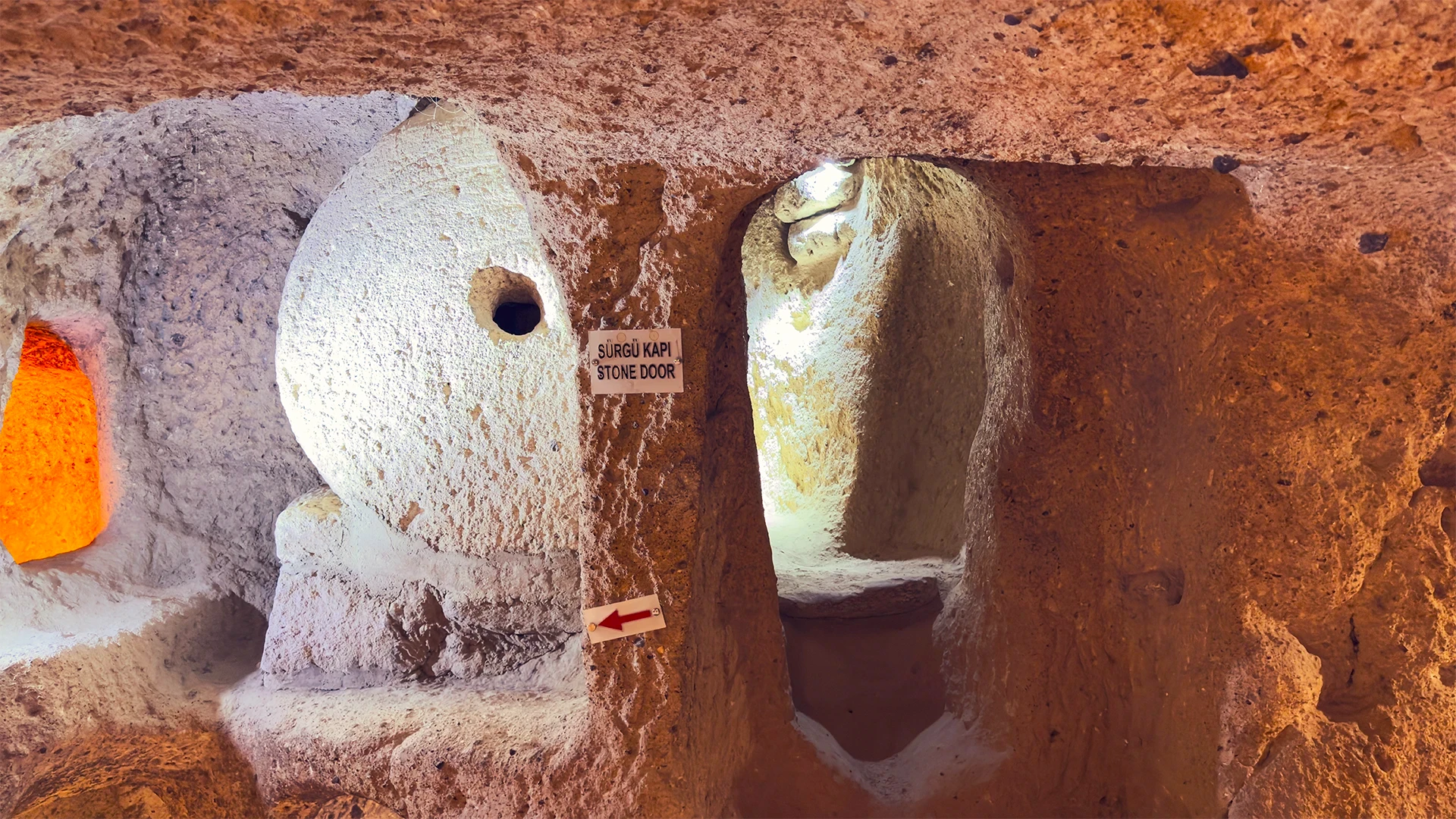
Large circular stone doors are among the most recognizable features of Cappadocia’s underground cities.
They are sometimes described dramatically as enormous “millstones,” although their primary architectural function was defensive.
The older source records circular blocking stones that could be moved from inside the underground settlement to close strategic passages. Small openings through some of these stones allowed people inside to observe or potentially interact with the corridor beyond.
Their position is particularly important.
These doors were not limited to the outer entrance.
They could appear deeper inside the complex.
That allowed a settlement to be divided into successive defensive zones.
If one section was reached, another corridor could still be closed.
Defence therefore worked through layers of controlled access.
The Underground City Was Designed to Slow an Intruder
Above-ground fortifications usually try to prevent an enemy from crossing a wall.
Underground architecture could use a different strategy.
It reduced freedom of movement.
A person entering a narrow passage had limited room to turn.
Groups could not advance side by side.
An unfamiliar layout created confusion.
Stone doors could close internal routes.
Alternative passages might remain known only to the community using the settlement.
The defensive value came from the combination of these elements rather than from any one feature.
This is why the underground cities should not be imagined simply as deep caves with hidden entrances.
They were controlled spatial systems.
Communication Between Levels
The older archaeological survey also describes small openings between floors and rooms that may have facilitated communication without requiring someone to travel through long corridors.
Özkonak is especially notable for this type of feature.
Its documented narrow openings between underground levels distinguish it from the more familiar layouts at Kaymaklı and Derinkuyu.
Such openings could potentially serve several purposes: airflow, voice communication, observation, or coordination between different parts of the underground settlement.
Their exact function may not always be recoverable.
What matters is that vertical communication appears to have been considered alongside physical movement.
How Was the Underground City Lit?
Natural light disappears quickly below the entrance levels.
Underground life therefore depended on artificial illumination.
The older archaeological source records niches and areas associated with lamps and describes the use of oil lamps within underground rooms.
Lighting created another reason ventilation mattered.
Any flame consumes oxygen and produces smoke.
The architecture needed to support both human occupation and the lamps required to make that occupation possible.
Modern electric lighting makes today’s visitor routes appear much brighter than the original underground environment would have been.
Historically, illumination would have been limited and localized.
That changes how the spaces should be imagined.
These were not brightly lit subterranean halls.
They were enclosed environments illuminated selectively where activity required it.
Sanitation Was Also Considered
Toilets are rarely emphasized in popular descriptions of Cappadocia’s underground cities, partly because clear examples are not common.
The older archaeological survey notes that toilet facilities had not been identified in most underground settlements known at the time, while citing examples at Tatlarin and Güzelyurt where such features had been documented.
Tatlarin is particularly interesting because official documentation also records an underground toilet reached through an angled corridor.
The rarity of such features is itself informative.
Waste management remains one of the more difficult aspects of reconstructing underground life.
Archaeologists can identify churches, stables, storage rooms and wells much more easily than everyday sanitation practices.
Where evidence is incomplete, it is better not to invent a solution.
Churches Reveal the Social Dimension of Refuge
Religious spaces occur in several major underground settlements.
Their presence is particularly important for understanding Byzantine use.
A community seeking protection below ground did not abandon every aspect of social and religious life.
Churches and chapels allowed worship to continue within the protected environment.
Kaymaklı contains a church on one of its accessible levels.
Derinkuyu includes significant religious spaces.
Saint Mercurius and Tatlarin make religious architecture even more prominent.
The exact dating of every church does not necessarily establish the date of the surrounding underground rooms, because later communities could modify existing complexes.
But their presence provides clear evidence that some subterranean settlements became integrated into Christian communal life.

Daily Life Below Ground Was Probably Temporary but Highly Organized
The architecture suggests communities capable of maintaining essential activities below ground for meaningful periods.
Animals could be sheltered.
Food could be prepared.
Wine and grain could be stored.
Water could remain accessible.
Religious activity could continue.
Ventilation sustained deeper rooms.
Defensive barriers controlled access.
This does not prove that thousands of people permanently lived underground.
It demonstrates something more plausible and arguably more impressive:
communities created a second layer of settlement beneath their ordinary lives, capable of supporting them when the surface became unsafe.
The older archaeological source is particularly valuable here because its drawings and observations show the underground environment not as a mysterious hidden civilization but as a highly practical arrangement of stables, kitchens, storage rooms, corridors, shafts and protected spaces.
That practical logic becomes easier to see when the major underground settlements are compared individually.
The next section begins with Derinkuyu and Kaymaklı, then moves across Cappadocia to Özkonak, Mazı, Tatlarin and the important underground settlements extending into Aksaray, Kayseri and Niğde.
Major Underground Cities of Cappadocia
The underground settlements of Cappadocia differ too much to be understood through Derinkuyu and Kaymaklı alone.
Some are deeper, some are wider, some preserve unusual defensive systems.
Others contain prominent churches, large storage areas or architectural features that suggest more specialized functions.
For travellers, this matters because visiting a second underground city is not necessarily a repetition of the first. The experience changes according to layout, depth, preserved spaces and how the settlement developed.
Derinkuyu Underground City
Derinkuyu Underground City is the best-known example of Cappadocia’s vertical subterranean architecture.
The Turkish Museums authority gives its approximate depth as 85 metres and describes an eight-level underground complex containing the principal elements associated with large Cappadocian settlements, including stables, storage areas, food-production spaces, religious rooms and a deep shaft connected with ventilation and water. (T.C. Kültür ve Turizm Bakanlığı)
The older archaeological source you provided describes the same general arrangement in greater spatial detail. Stables and working areas occur closer to the entrance, while increasingly protected rooms extend deeper underground. Its photographs and plans also make the vertical change in scale particularly clear.
What distinguishes Derinkuyu most strongly is not simply its depth.
It is the experience of descending through a sequence of increasingly enclosed spaces.
What Makes Derinkuyu Different?
Official documentation distinguishes Derinkuyu from Kaymaklı through several features, including a large religious or instructional space traditionally described as a missionary school, a baptismal area and its substantial well system. (T.C. Kültür ve Turizm Bakanlığı)
The 55-metre shaft recorded by the Nevşehir Museum authorities served both ventilation and water-related functions. Some wells were arranged so that lower sections were not directly exposed to the surface, which would have reduced vulnerability during periods of danger. (Nevşehir Kültür ve Turizm Müdürlüğü)
Only a portion of the complete underground complex is accessible today. Official regional documentation states that roughly 10 percent of Derinkuyu is currently open to visitors. (Nevşehir Kültür ve Turizm Müdürlüğü)
That is worth remembering when standing inside it.
The visitor route does not represent the entire settlement.
It is a controlled path through a much larger subterranean system.
For a deeper explanation of the levels, architecture and practical visitor experience, see our Derinkuyu Underground City Guide.
Kaymaklı Underground City
Kaymaklı Underground City presents a very different architectural experience.
Official Turkish Museums information describes Kaymaklı as the widest among the explored underground cities of Cappadocia. Four levels are currently illuminated for visitors, although the settlement extends beyond the accessible route. (T.C. Kültür ve Turizm Bakanlığı)
Its plan is more horizontally distributed than Derinkuyu.
Rooms and working spaces cluster around major ventilation shafts, and the route moves repeatedly through low, narrow passages between wider chambers.
The older archaeological source emphasizes the same distinction. Its Kaymaklı section shows stables near the upper level, a church below, and a concentration of kitchens, wineries and storage spaces further into the explored system.
Storage Is One of Kaymaklı’s Defining Features
Kaymaklı contains a particularly large number of storage spaces within the explored area.
The Turkish Museums authority specifically points to this concentration as evidence that the settlement could support a substantial community. (T.C. Kültür ve Turizm Bakanlığı)
The third accessible level is especially informative.
Official documentation identifies kitchens, wine-production areas, storage rooms and a large stone installation associated with crushing or processing. (T.C. Kültür ve Turizm Bakanlığı)
This helps explain why Kaymaklı is so valuable for understanding underground life.
Derinkuyu creates the stronger impression of depth.
Kaymaklı often makes daily function easier to read.
Food, animals, storage, production, ventilation, and religious space.
All remain visibly connected within a comparatively compact underground network.
For a more detailed floor-by-floor explanation, continue with our Kaymaklı Underground City Guide.
Kaymaklı and Derinkuyu Are Not Versions of the Same City
These two sites are often compared only by size.
That is too simplistic.
A more useful distinction is architectural.
Derinkuyu emphasizes vertical depth and increasingly protected lower levels.
Kaymaklı emphasizes interconnected spaces distributed more broadly around ventilation systems.
Both contain many of the same functional categories, but the spatial experience is different.
This is one reason travellers with a strong interest in rock-cut architecture may find it worthwhile to visit both.
The second site becomes meaningful when the visitor is looking for the differences rather than another example of the same thing.
Özkonak Underground City
Özkonak lies approximately 14 kilometres from Avanos on the northern slopes of İdiş Mountain.
It is particularly important because its defensive and communication features differ from those at Kaymaklı and Derinkuyu.
The Turkish Museums authority notes that the explored galleries extend across a broad area and are connected by tunnels. More unusually, narrow elongated openings between floors allowed communication and continued ventilation even when individual rooms were closed. (T.C. Kültür ve Turizm Bakanlığı)
These openings are one of Özkonak’s defining architectural features.
They show that underground settlements did not rely solely on corridors for communication between levels.
Why Is Özkonak Different?
The official description explicitly contrasts Özkonak with Kaymaklı and Derinkuyu.
Its narrow vertical or angled openings connected levels and maintained airflow, introducing another way to organize communication and defence within an enclosed settlement. (T.C. Kültür ve Turizm Bakanlığı)
Nevşehir Museum documentation also records rolling stone doors and additional openings beyond them. Older interpretations suggested that these might have had defensive uses, including pouring liquids onto intruders, although such explanations should be treated as hypotheses rather than proven functions. (Nevşehir Kültür ve Turizm Müdürlüğü)
That distinction is important.
The physical openings are real.
Their exact use in every circumstance is harder to prove.
Özkonak is therefore best understood as evidence of regional variation in underground engineering, not as proof of one dramatic defensive technique.
Mazı Underground City
Mazı lies south of Ürgüp and east of Kaymaklı.
Its ancient name is recorded as Mataza, and Nevşehir Museum authorities have identified four separate entrances into the underground settlement. (Nevşehir Kültür ve Turizm Müdürlüğü)
That alone makes Mazı interesting.
Many popular descriptions of Cappadocia’s underground cities emphasize concealed single entrances, but Mazı demonstrates a more complex relationship between the underground system and the surface settlement.
The main entrance passes through a corridor that could be controlled by a large rolling stone.
Beyond it, extensive stable areas occupy substantial sections of the upper underground complex.
A short corridor then leads toward a church whose entrance could also be closed from within. (Nevşehir Kültür ve Turizm Müdürlüğü)
Mazı Shows How Entrances Could Be Part of the Settlement Plan
The four identified entrances suggest that access was not necessarily organized around one hidden doorway.
Different entrances may have served different sections or functions.
This is another reason the image of the underground city as one secret tunnel leading into a buried settlement should be treated cautiously.
At Mazı, the relationship between surface and underground appears more distributed.
Its broad stable areas also reinforce the agricultural character of these settlements.
Animals were not an incidental addition to the refuge system.
They were part of the economic life that communities needed to protect.
The Church at Mazı
Mazı’s church also differs architecturally from the church at Kaymaklı.
Nevşehir Museum documentation notes that its apse was carved into a different position within the chamber and that the façade contains relief decoration. (Nevşehir Kültür ve Turizm Müdürlüğü)
This may seem like a small detail, but it illustrates a larger pattern.
Religious architecture inside Cappadocia’s underground settlements was not standardized.
Churches were adapted to the space available and to the different phases in which individual complexes developed.
Mazı therefore helps demonstrate that underground architecture was shaped locally rather than reproduced from a single template.
Tatlarin Underground City
Tatlarin is one of the most unusual underground settlements in Cappadocia.
Located near Acıgöl beneath the hill known locally as Kale, the complex extends across a large area, but only a small part has been cleared and two levels are currently accessible. (Nevşehir Kültür ve Turizm Müdürlüğü)
The scale and character of its rooms have led archaeologists to question whether Tatlarin functioned like a conventional refuge settlement at all.
Nevşehir Museum authorities specifically note: the unusually large spaces, numerous storage rooms, multiple churches, and rare toilet facilities
as reasons to consider whether Tatlarin may have served as a military garrison or monastic complex. (Nevşehir Kültür ve Turizm Müdürlüğü)
This is one of the strongest examples in Cappadocia of why the label “underground city” can obscure functional differences.
Tatlarin Contains Rare Sanitation Evidence
One of Tatlarin’s most distinctive features is an underground toilet reached through an L-shaped corridor.
Nevşehir Museum archaeologists suggest that the angled passage may have helped reduce the movement of unpleasant odours into adjoining spaces. (Nevşehir Kültür ve Turizm Müdürlüğü)
This is valuable evidence because sanitation is one of the most difficult aspects of underground life to reconstruct.
Stables are recognizable.
Churches are recognizable.
Storage rooms can often be interpreted through their shape and installations.
Waste management leaves less obvious archaeological evidence.
Tatlarin therefore contributes information that is uncommon elsewhere in the underground-city network.
Defensive Pits at Tatlarin
Tatlarin also contains another unusual feature.
Official documentation records pits approximately two to three metres deep positioned in some corridors and interprets them as defensive traps. (Kültür Varlıkları Müdürlüğü)
This differs from the more familiar defence system of narrow passages and rolling stones.
Again, not every underground settlement solved the same problem in the same way.
Tatlarin appears to have developed a particularly specialized internal architecture.
The Churches at Tatlarin
Religious use around Tatlarin is especially prominent.
The nearby church complex preserves paintings including the Virgin and Child, the Transfiguration, the Crucifixion, Archangels Michael and Gabriel, Constantine and Helena and several saints.
The surviving painted programme is generally dated to the early 13th century. (Nevşehir Kültür ve Turizm Müdürlüğü)
This does not mean every underground room at Tatlarin belongs to the same date.
It does show that the wider complex continued to have important Christian associations well into the medieval period.
That layered use is typical of Cappadocia.
A subterranean settlement could be older than one of the churches associated with it, while later communities continued adapting the same carved landscape.
What These Five Underground Cities Already Reveal
Even before moving beyond Nevşehir, the diversity is clear.
Derinkuyu demonstrates exceptional vertical depth.
Kaymaklı reveals a broader interconnected settlement with extensive storage and production areas.
Özkonak preserves distinctive communication and ventilation features.
Mazı shows multiple entrances, extensive stables and a different religious layout.
Tatlarin may represent a more specialized monastic or military complex and contains unusual sanitation and defensive features.
These differences make one conclusion difficult to avoid:
there was no single Cappadocian underground-city blueprint.
The underground landscape developed through different communities, periods, practical needs and local conditions.
The next part will move beyond Nevşehir into the wider Cappadocia region, examining Saratlı Kırkgöz, Saint Mercurius, Gaziemir and Çukurören in Aksaray, followed by the underground settlements around Kayseri and Niğde.
Underground Cities of Aksaray: Western Cappadocia Beyond Nevşehir
The underground-city tradition continues west of Nevşehir into modern Aksaray Province, where several important subterranean settlements survive across the wider Cappadocia region.
These sites are especially valuable because they broaden the architectural picture.
Some resemble the defensive refuge systems already seen at Kaymaklı and Derinkuyu.
Others give greater prominence to churches, burial spaces, production areas or accommodation functions.
Aksaray’s official cultural inventory records numerous underground settlements across the province, including Saratlı Kırkgöz, Saint Mercurius, Gaziemir and Çukurören. (Aksaray Kültür ve Turizm Müdürlüğü)
Saratlı Kırkgöz Underground City
Saratlı Kırkgöz is one of the principal underground cities on the western side of Cappadocia.
Three levels have been cleared and prepared for visitors, while the larger complex is thought to continue beyond the accessible areas. The explored sections contain approximately forty rooms together with stables, wells, ventilation shafts, food-preparation areas and defensive passages. (Aksaray Kültür ve Turizm Müdürlüğü)
The entrance immediately illustrates the practical organization of underground life.
The first area contains a stable with fourteen feeding troughs, followed by another animal space with seven more.
This concentration of livestock near the entrance follows the same general logic seen elsewhere in Cappadocia.
Animals remained relatively close to the surface.
Deeper rooms could then serve people, storage and more protected functions.
Water, Cooking and Ventilation at Saratlı
The second accessible level contains a well approximately ten metres deep.
A ventilation shaft rises above it, while a tandır, or traditional oven, was carved into the floor nearby. Additional rooms extend from the same area, and unfinished tunnels show that sections of the complex were either still expanding or were never completed. (Aksaray Kültür ve Turizm Müdürlüğü)
A sloping tunnel leads toward the third level and another water area traditionally known as Kuyulu Dam.
These features make Saratlı particularly useful for understanding how several essential systems could be concentrated around one underground zone: water, air, food preparation, movement, and protected rooms.
The architecture is less dramatic in depth than Derinkuyu, but it is highly informative in terms of daily function.
Saint Mercurius Underground City and Church
Saratlı contains a second major subterranean complex known as Saint Mercurius Underground City and Church.
Its character differs considerably from Kırkgöz because religious architecture occupies a much more prominent position.
Official Aksaray documentation describes the underground settlement as extending through seven levels, three of which have been cleared and opened. The visitor route eventually connects with a substantial church rather than a small underground chapel. (Aksaray Kültür ve Turizm Müdürlüğü)
The church contains burials belonging to adults and children. Archaeological work exposed approximately twenty graves within the religious complex, while storage vessels were also recovered elsewhere in the underground settlement. (Aksaray Kültür ve Turizm Müdürlüğü)
This combination of: refuge, storage, church, and burial space
makes Saint Mercurius particularly important for understanding how subterranean architecture could become integrated with Christian communal life.
Saint Mercurius Requires Careful Dating
The official regional source associates Saint Mercurius strongly with the third-century Christian period and describes it as having been used as a refuge when Christianity was prohibited. (Aksaray Kültür ve Turizm Müdürlüğü)
This interpretation is valuable as local archaeological context, but it should be considered alongside the broader dating problem discussed earlier in this guide.
The existence of an early Christian tradition at a site does not necessarily prove that every underground level was excavated at exactly the same time.
As elsewhere in Cappadocia, the safer interpretation is that the complex may have developed through several phases, with religious use becoming particularly significant during later Christian occupation.
Gaziemir Underground City: A Different Kind of Subterranean Complex
Gaziemir is one of the most unusual underground sites in Cappadocia.
Its plan immediately differs from the narrow multi-level systems associated with Kaymaklı and Derinkuyu.
Visitors enter through a stone-built corridor into a central open area surrounded by subterranean rooms. The documented complex includes two churches, wine-production areas, numerous wine vessels, food-storage rooms, hearths, animal shelters and living spaces. (Aksaray Kültür ve Turizm Müdürlüğü)
But the most interesting feature is the interpretation of the overall layout.
Aksaray’s Provincial Directorate describes Gaziemir as having been organized in a manner comparable to a caravanserai, with long corridors containing spaces where travellers could rest. (Aksaray Kültür ve Turizm Müdürlüğü)
That changes the discussion significantly.
Gaziemir Challenges the Idea That Every Underground City Was a Refuge
If the caravanserai interpretation is correct, Gaziemir demonstrates that underground architecture could support travel, accommodation and commerce as well as defence.
Animals could be sheltered.
Wine could be processed and stored.
Travellers could rest.
Food could be kept underground.
Religious spaces remained present.
This does not mean security was unimportant.
It means that the underground environment could serve a much broader economic role than simply hiding a local population from attack.
Gaziemir is therefore one of the clearest examples of why the term underground city covers a range of different architectural functions.
Çukurören Underground City
Çukurören lies in the Gülağaç district of Aksaray in an area locally known as Yedi Kapılar, or Seven Gates.
Official regional documentation describes it as one of the largest underground complexes in Cappadocia by area and suggests that it was capable of accommodating hundreds of people. (Aksaray Kültür ve Turizm Müdürlüğü)
Its documented spaces are remarkably diverse.
They include: a church, wine-production areas, animal shelters, water wells, passages, tunnels, rolling stone doors, living spaces, and a bezirhane, an installation associated with oil production. (Aksaray Kültür ve Turizm Müdürlüğü)
This makes Çukurören especially useful for understanding the underground city as an integrated settlement system rather than a collection of defensive tunnels.
Production Was Part of the Underground Economy
Çukurören reinforces a pattern already visible at Kaymaklı and Gaziemir.
Underground architecture was connected directly with agricultural production.
Wine-processing areas point toward vineyards above ground.
Animal shelters connect the subterranean settlement with livestock.
The bezirhane indicates another form of processing activity.
Wells supplied water.
Storage protected provisions.
The underground city therefore depended on the same agricultural landscape that sustained the surface community.
This relationship is essential.
People could move below ground, but the economy that supported them remained rooted in fields, animals and resources outside.
Underground Cities Around Kayseri: The Eastern Cappadocian Network
The same subterranean tradition continues east toward Kayseri.
The official provincial inventory records underground settlements in and around Ağırnas, Subaşı, Gesi, Değirmendere Valley, Kırlangıç Valley, Talas, Tomarza, Yeşilhisar and Develi, among other locations. (Kayseri Kültür ve Turizm Müdürlüğü)
This is important because it confirms that underground architecture followed the broader geological and settlement landscape of Cappadocia rather than modern provincial boundaries.
The Kayseri authority also notes that the underground sites in this area differ in several respects from those around Nevşehir and Göreme. (Kayseri Kültür ve Turizm Müdürlüğü)
That regional variation is exactly what we should expect from a tradition that developed locally over long periods.
Ağırnas Underground City
Ağırnas is the best-known visitor-accessible example on the Kayseri side.
The historic settlement is also associated with Mimar Sinan, the great Ottoman architect who was born there, but the underground structures beneath Ağırnas belong to a much broader and older history of settlement.
Official Kayseri material describes Ağırnas as containing extensive tunnels, caves and underground remains beneath the modern settlement and notes that the underground city was cleaned and opened to visitors after conservation work. (Kayseri Kültür ve Turizm Müdürlüğü)
What makes Ağırnas particularly interesting is the relationship between underground and surface architecture.
The subterranean spaces are not isolated in a separate archaeological field.
They lie beneath a settlement that continued to develop above them.
This makes the original logic easier to understand.
The underground city was not another world.
It was part of the village.
Kayseri Contains Many More Subterranean Sites
Ağırnas represents only one part of the eastern network.
The provincial inventory includes underground settlements at Çatalin, Penzikli, Ötedere, Zincidere, Tomarza, Güzelöz and several other locations. (Kayseri Kültür ve Turizm Müdürlüğü)
Most are not prepared for regular tourism.
The Kayseri authority states that Ağırnas is currently the principal underground-city area in the province open to visitors, while other sites remain under documentation, cleaning or conservation processes. (Kayseri Kültür ve Turizm Müdürlüğü)
This distinction matters throughout Cappadocia.
Identified does not mean accessible.
A documented underground settlement may contain collapsed passages, unstable rooms or areas that have never been conserved for public entry.
Travellers should therefore never enter unofficial subterranean spaces simply because an opening is visible.
Niğde and the Southern Cappadocian Context
South of the central Cappadocia plateau, Niğde provides another important example of how underground architecture could exist alongside larger rock-cut religious complexes.
The strongest example is Gümüşler.
Gümüşler Monastery and Its Underground Spaces
Gümüşler Monastery is best known for its rock-cut church, courtyard plan and surviving Byzantine wall paintings.
Niğde’s official cultural authority describes it as one of the largest and best-preserved rock-cut monasteries in the Cappadocia region. (Niğde Kültür ve Turizm Müdürlüğü)
But the monastery also includes a subterranean component.
Official site documentation records an underground city on the left side of the entrance courtyard. The underground area contains ventilation extending toward the surface and a feature described by the provincial authority as a megaphone-like communication system between the subterranean spaces and the surface. (Niğde Kültür ve Turizm Müdürlüğü)
This is particularly valuable because the underground architecture is not the dominant feature of Gümüşler.
It exists as one component within a larger monastic environment.
Gümüşler Shows How Artificial Categories Can Be Misleading
Modern travel literature often separates Cappadocia into categories: underground cities, cave churches, monasteries, rock-cut houses.
The historical landscape was not always divided so neatly.
At Gümüşler, a monastery, church, courtyard, storage areas, burials and underground rooms coexist within one architectural complex. (Niğde Kültür ve Turizm Müdürlüğü)
This reinforces the argument made at the beginning of this guide.
Cappadocia’s underground settlements belong to a broader rock-cut architectural culture.
Some spaces descended vertically.
Others were carved laterally into cliffs.
Still others combined both approaches.
The techniques changed according to function and geology rather than according to modern tourism categories.
For the monastery’s architecture, paintings and visitor information, continue with our complete Gümüşler Monastery Guide.
What the Wider Underground Network Tells Us
Once Nevşehir, Aksaray, Kayseri and Niğde are considered together, Cappadocia’s subterranean landscape becomes much more difficult to reduce to one explanation.
Derinkuyu is remarkable for vertical depth.
Kaymaklı reveals a broad interconnected plan with extensive storage and production spaces.
Özkonak preserves unusual communication features.
Mazı contains multiple entrances and extensive stable areas.
Tatlarin may have served specialized religious or military functions.
Saratlı Kırkgöz demonstrates another integrated refuge system.
Saint Mercurius gives unusual prominence to church and burial space.
Gaziemir may reflect accommodation and caravan-route functions.
Çukurören combines living, production, livestock, water and defence on a large scale.
Ağırnas demonstrates how subterranean spaces could remain embedded beneath a continuing settlement.
Gümüşler connects underground architecture directly with a major monastic complex.
The diversity matters more than identifying one city as the largest, oldest or most mysterious.
Taken together, these sites show that Cappadocia’s underground architecture was adaptive rather than standardized.
Communities used the same geological opportunity in different ways according to location, period, security and economic needs.
The next section turns from archaeology to the visitor’s decision: which underground city should you visit, how Kaymaklı and Derinkuyu compare in practice, what the experience feels like underground, and what to know about narrow passages, claustrophobia and physical difficulty before entering.
Which Underground City Should You Visit in Cappadocia?
There is no single underground city that is best for every traveller.
The right choice depends on what you want to understand, how comfortable you are in confined spaces and how the site fits into the rest of your Cappadocia route.
For most first-time visitors, the decision is between Kaymaklı and Derinkuyu.
Travellers returning to Cappadocia, or those with a stronger interest in subterranean architecture, may find Özkonak, Mazı or Tatlarin particularly valuable because each reveals a different aspect of the underground tradition.
Kaymaklı or Derinkuyu?
The two most famous underground cities are often presented as interchangeable.
They are not.
Choose Derinkuyu if you are most interested in depth
Derinkuyu Underground City creates the stronger sense of descending deep below the surface.
Its vertical organization, narrow connections between levels, water and ventilation infrastructure and increasingly protected spaces make the architecture feel distinctly defensive.
For travellers fascinated by the scale of subterranean construction, Derinkuyu usually creates the more dramatic first impression.
Choose Kaymaklı if you want to understand daily function
Kaymaklı Underground City is more horizontally interconnected and makes several aspects of underground life particularly easy to interpret.
Stables, storage rooms, kitchens, wine-production areas, religious space and ventilation infrastructure appear within a comparatively compact visitor route.
For travellers interested in how a community actually organized life below ground, Kaymaklı can be the more revealing choice.
Should You Visit Both?
You can, but it is not necessary for every traveller.
If your Cappadocia itinerary is limited to two or three days, one underground city is usually enough. The second day is often better used for Göreme Open Air Museum, a valley walk, village exploration or another part of Cappadocia’s cultural landscape.
Visiting both becomes more worthwhile when underground architecture is a particular interest and you actively want to compare their different layouts.
The value lies in the comparison, not simply in saying that you entered two underground cities.
What About Özkonak, Mazı and Tatlarin?
The lesser-known sites become especially interesting once you already understand the basic underground-city system.
Özkonak is a strong choice for travellers interested in defensive engineering and communication between different levels.
Mazı offers another spatial arrangement, with multiple entrances, extensive stable areas and distinctive religious architecture.
Tatlarin is particularly valuable for travellers interested in unusual functions because its large rooms, churches, sanitation facilities and defensive features have led archaeologists to consider whether parts of the complex served monastic or military purposes.
These sites should not be described simply as quieter alternatives to Derinkuyu and Kaymaklı.
Their real value is that they reveal different solutions within the same subterranean architectural tradition.
What Does It Feel Like Inside an Underground City?
Modern visitor routes are illuminated and controlled, but the physical environment remains very different from ordinary archaeological sites.
Expect: low ceilings, narrow passages, steep steps, uneven surfaces, limited natural light, and periods of single-file movement.
Some corridors require visitors to bend significantly while walking.
The temperature below ground also tends to feel cooler and more stable than conditions outside.
This physical experience is part of understanding the architecture.
The underground settlements were not designed for sightseeing comfort. Their passages were functional spaces shaped by excavation efficiency, defence and controlled movement.
Are the Underground Cities Claustrophobic?
They can be.
Travellers who are uncomfortable in enclosed spaces should take this seriously rather than assuming the experience will feel like entering a conventional cave.
Sections of the visitor routes can be: narrow, low, crowded, and far from visible daylight.
Turning back may not always be immediately possible once you enter a one-way section of the route.
If you have significant claustrophobia, respiratory difficulties, balance concerns or difficulty bending and climbing stairs, discuss the visit before entering.
Seeing an underground city is an important Cappadocia experience, but it is not essential at the expense of personal comfort.
The region contains many other ways to understand its rock-cut heritage above ground.
How Physically Difficult Is an Underground City Visit?
The main challenge is usually not distance.
It is the combination of: stairs, low tunnels, restricted movement, changes in level, and prolonged bending in certain passages.
Visitors with normal mobility generally manage established routes without difficulty, but the experience can become tiring for people with knee, back or balance problems.
Footwear with secure grip is preferable.
Large bags are also inconvenient in narrow passages and should be avoided where possible.
How Long Should You Allow?
For most visitors, approximately one to one and a half hours is sufficient for a well-paced underground-city visit when interpretation and normal movement through the site are included.
The exact time depends on: which underground city you visit, crowd levels, your walking pace, and how much explanation you want.
Trying to move through the site as quickly as possible misses much of what makes the architecture interesting.
The narrow corridors attract attention immediately, but rooms associated with storage, animals, ventilation and religious life are what explain how the system functioned.
When Is the Best Time to Visit?
Underground cities can be visited throughout the year.
Because the environment below ground remains comparatively stable, the experience is less affected by heat, cold or rain than an outdoor archaeological site.
The more important consideration is visitor density.
At the best-known sites, arriving earlier or choosing a period outside the busiest part of the day can make narrow sections significantly more comfortable.
This matters particularly at Kaymaklı and Derinkuyu, where groups may need to move through restricted passages in sequence.
Stay on the Official Visitor Route
Only underground settlements prepared and maintained for visitors should be entered.
Many subterranean spaces across Cappadocia remain: uncleared, unstable, partially collapsed, or archaeologically sensitive.
An opening in a hillside or beneath a village does not mean that the space is safe to explore.
Established visitor routes protect both travellers and the archaeological structure.
The underground landscape is extensive precisely because much of it remains outside normal tourism access.
How Underground Cities Fit Into a Cappadocia Itinerary
An underground-city visit works best when it is combined with a contrasting part of the region.
After spending time below ground, seeing Cappadocia’s valleys, villages or churches above the surface makes the relationship between geology and settlement much easier to understand.
The Green Tour Cappadocia incorporates an underground-city visit within a broader southern Cappadocia route, while the Highlights of Cappadocia Tour provides a wider introduction to the region’s principal landscapes and cultural heritage.
Travellers spending several days in the region can explore the underground landscape within a more complete framework through our 3 Days Cappadocia Tour or 5 Days Cappadocia Tour.
Travellers who want to combine underground heritage with a more active exploration of Cappadocia can include Kaymaklı Underground City within the Cappadocia Hiking Tour • Valleys & Local Experiences. The five-day route pairs Kaymaklı with longer walks through Ihlara Valley and Avla Canyon, as well as Red, Swords and Görkündere valleys, while still including Göreme Open Air Museum, Soğanlı Valley, Paşabağ and Zelve.
Travellers who want to experience Cappadocia’s underground heritage within a longer journey across Turkey can also visit Kaymaklı Underground City as part of the 15-Day Turkey Tour • Istanbul, Cappadocia & Mesopotamia. The itinerary allows four nights in Cappadocia, combining Kaymaklı with Göreme Open Air Museum, Red Valley, Mustafapaşa, Keşlik, Sobesos and Soğanlı before continuing overland toward Gaziantep and Southeastern Turkey.
The objective should not be to place an underground city into the itinerary simply because it is famous.
Its real value appears when the visit helps explain the larger story of Cappadocia: a landscape in which communities repeatedly adapted the same volcanic rock above ground, inside cliffs and beneath the earth.
FAQ: Underground Cities of Cappadocia
How Many Underground Cities Are There in Cappadocia?
The exact number is not known.
Turkish museum authorities generally estimate that around 150 to 200 underground settlements exist across the wider Cappadocia region, while recent specialist research has documented more than 200 subterranean shelters and settlements. Only a small proportion have been excavated, conserved and prepared for regular visitors.
The older archaeological study used in this guide also recorded an estimated 150 to 200 underground settlements, showing that the scale of Cappadocia’s subterranean landscape has been recognized for decades.
Which Is the Largest Underground City in Cappadocia?
There is no simple answer because “largest” can refer to depth, horizontal extent or the total area of an underground system, much of which may remain unexplored.
Derinkuyu is the best-known deep underground city and reaches approximately 85 metres below the surface.
Kaymaklı is described by Turkish museum authorities as the widest among the explored underground cities of Cappadocia.
For travellers, the architectural difference between the two is more meaningful than trying to assign one absolute size ranking.
Which Is Deeper, Kaymaklı or Derinkuyu?
Derinkuyu is considerably deeper.
Its known underground system reaches approximately 85 metres and extends through multiple levels.
Kaymaklı spreads more broadly through interconnected spaces and is particularly valuable for understanding storage, food production, stables and everyday functions within an underground settlement.
For detailed comparisons, see our guides to Derinkuyu Underground City and Kaymaklı Underground City.
Who Built the Underground Cities of Cappadocia?
No single civilization can be identified confidently as the builder of every underground city.
Some official interpretations connect early phases of subterranean activity with the Hittites, while rock-cut architecture continued during Roman and Early Christian periods.
The clearest evidence for the development of large defensive underground systems belongs to the Byzantine period, particularly between approximately the 7th and 11th centuries, when Central Anatolia experienced repeated military pressure and Arab raids.
Many underground settlements were probably expanded and reused over several centuries rather than constructed during one historical period.
Were the Underground Cities Built by Christians?
Christians played an important role in the later history of many underground settlements, particularly during the Byzantine period.
Churches and other religious spaces survive inside several complexes, and UNESCO specifically associates Kaymaklı and Derinkuyu with communities seeking refuge during periods of conflict.
However, this does not prove that Christians created every underground room from the beginning.
Earlier subterranean spaces may have been incorporated into larger systems and adapted for new purposes over time.
Did People Permanently Live Underground in Cappadocia?
Probably not.
The most convincing interpretation is that the underground systems remained connected with settlements on the surface.
People farmed, raised animals and conducted ordinary life above ground, while subterranean spaces could serve as storage, production areas, cellars and animal shelters during normal periods.
When danger increased, larger sections could support communities temporarily below ground.
The term underground city should therefore not be understood as a civilization permanently separated from the surface.
How Long Could People Stay Underground?
There is no reliable archaeological evidence establishing a fixed number of days or months.
The presence of ventilation shafts, wells, storage rooms, kitchens, wineries, stables and religious spaces shows that the larger settlements were designed for more than a brief hiding period.
What cannot be established confidently is exactly how long individual communities remained underground during specific historical events.
Were Kaymaklı and Derinkuyu Connected by a Secret Tunnel?
Long tunnels and passages exist within Cappadocia’s underground settlements, but popular claims describing a proven underground connection between major cities over many kilometres should be treated cautiously.
No region-wide subterranean network linking all of Cappadocia’s famous underground cities has been archaeologically demonstrated.
What has been documented is already remarkable: hundreds of separate subterranean settlements developed across the same geological and historical landscape.
Are Cappadocia’s Underground Cities Safe to Visit?
The major underground cities open to the public are visited through designated routes maintained for tourism.
Visitors should remain within these established areas.
Many other underground spaces across Cappadocia are partially collapsed, archaeologically sensitive or have never been prepared for public access.
Do not enter unofficial tunnels, caves or underground openings simply because they appear accessible.
Are the Underground Cities Suitable for People With Claustrophobia?
Not always.
Parts of the visitor routes include low ceilings, narrow tunnels, steep steps and sections where visitors move in single file.
Anyone with significant claustrophobia, respiratory difficulties, balance problems or difficulty bending should consider the physical environment carefully before entering.
An underground-city visit is valuable, but it is not the only way to understand Cappadocia’s rock-cut heritage.
Can You Visit More Than One Underground City in a Day?
It is possible, but most first-time visitors do not need to.
Kaymaklı and Derinkuyu share several broad architectural functions, even though their layouts differ significantly.
Unless subterranean architecture is a particular interest, one underground city combined with valleys, churches or surface settlements generally creates a more varied Cappadocia day.
Which Underground Cities Are Open to Visitors?
Kaymaklı and Derinkuyu are the most established visitor sites, while other underground settlements including Özkonak, Mazı, Tatlarin and selected sites in Aksaray can also be accessible depending on current conservation and visitor arrangements.
Opening conditions can change.
Before travelling specifically to a lesser-known site, check the current information provided by the relevant Turkish museum or provincial cultural authority.
Understanding Cappadocia Above and Below the Surface
The underground cities are extraordinary, but they become more meaningful when they are understood as part of Cappadocia rather than as isolated monuments.
The volcanic rock that produced the region’s valleys and fairy chimneys also made extensive rock-cut architecture possible.
The communities that carved churches into cliffs, created storage rooms inside valleys and adapted natural formations into homes were working with the same landscape when they excavated protected spaces beneath their settlements.
Kaymaklı, Derinkuyu and the lesser-known underground complexes therefore reveal another dimension of the same relationship between geology and human adaptation.
Above ground, Cappadocia tells its story through valleys, villages, vineyards and rock-cut churches.
Below ground, the same story continues through ventilation shafts, stables, storage rooms, wells, churches and defensive passages.
Together, they explain why Cappadocia should be understood not simply as a landscape shaped by nature, but as a landscape repeatedly reshaped by the people who lived within it.
For the wider regional story, including valleys, cave architecture, Byzantine heritage, local experiences and practical planning, continue with our Cappadocia Travel Guide.
Travellers who want to explore the region within a structured private itinerary can also compare our Private Turkey Tours and Cappadocia routes.
WRITTEN BY

Nisa Buket Dağdelen
Operations Director & Tour Guide
LinkedIn Profile

Hüseyin Pekgöz
Founder & Managing Partner
LinkedIn Profile
Adventus Travel Company


